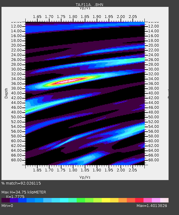
F11A Grangeville, ID, USA - Earthquake Result Viewer

Earthquake location: Andreanof Islands, Aleutian Is.
Earthquake latitude/longitude: 50.3/-177.5
Earthquake time(UTC): 2007/08/15 (227) 20:22:11 GMT
Earthquake Depth: 9.0 km
Earthquake Magnitude: 6.3 MB, 6.2 MS, 6.4 MW, 5.9 ML
Earthquake Catalog/Contributor: WHDF/NEIC
Network: TA USArray Transportable Network (new EarthScope stations)
Station: F11A Grangeville, ID, USA
Lat/Lon: 45.89 N/116.15 W
Elevation: 1186 m
Distance: 40.2 deg
Az: 71.763 deg
Baz: 299.35 deg
Ray Param: 0.074525416
Estimated Moho Depth: 34.75 km
Estimated Crust Vp/Vs: 1.78
Assumed Crust Vp: 6.571 km/s
Estimated Crust Vs: 3.697 km/s
Estimated Crust Poisson's Ratio: 0.27
Radial Match: 92.026115 %
Radial Bump: 344
Transverse Match: 83.49962 %
Transverse Bump: 400
SOD ConfigId: 2564
Insert Time: 2010-03-07 03:59:49.301 +0000
GWidth: 2.5
Max Bumps: 400
Tol: 0.001

Signal To Noise

ChannelStoNSTALTA
TA:F11A: :BHN:20070815T20:29:17.000005Z4.07752569.431895E-72.3131419E-7
TA:F11A: :BHE:20070815T20:29:17.000005Z13.3798281.1473487E-68.575213E-8
TA:F11A: :BHZ:20070815T20:29:17.000005Z25.4413152.324447E-69.136506E-8
Arrivals
Ps4.4 SECOND
PpPs14 SECOND
PsPs/PpSs18 SECOND