You are here: Home > Network List > TA - USArray Transportable Network (new EarthScope stations) Stations List
> Station F11A Grangeville, ID, USA > Earthquake Result Viewer
F11A Grangeville, ID, USA - Earthquake Result Viewer
| Earthquake location: |
Sakhalin, Russia |
| Earthquake latitude/longitude: |
47.1/141.8 |
| Earthquake time(UTC): |
2007/08/02 (214) 02:37:42 GMT |
| Earthquake Depth: |
5.0 km |
| Earthquake Magnitude: |
6.2 MS, 5.3 MB, 6.2 MW, 6.2 MW |
| Earthquake Catalog/Contributor: |
WHDF/NEIC |
|
| Network: |
TA USArray Transportable Network (new EarthScope stations) |
| Station: |
F11A Grangeville, ID, USA |
| Lat/Lon: |
45.89 N/116.15 W |
| Elevation: |
1186 m |
|
| Distance: |
65.0 deg |
| Az: |
48.931 deg |
| Baz: |
312.508 deg |
| Ray Param: |
0.05859346 |
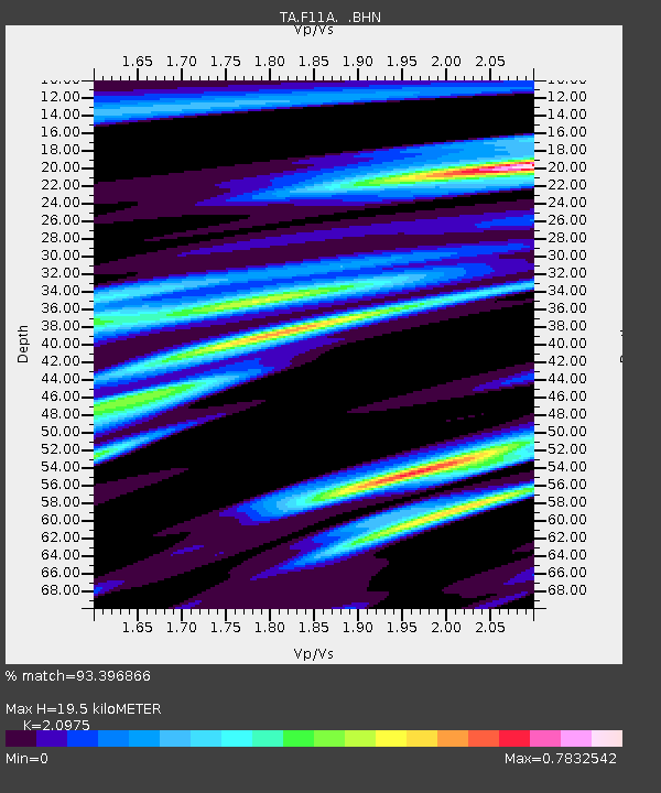
| Estimated Moho Depth: |
19.5 km |
| Estimated Crust Vp/Vs: |
2.10 |
| Assumed Crust Vp: |
6.571 km/s |
| Estimated Crust Vs: |
3.133 km/s |
| Estimated Crust Poisson's Ratio: |
0.35 |
|
| Radial Match: |
93.396866 % |
| Radial Bump: |
400 |
| Transverse Match: |
78.014694 % |
| Transverse Bump: |
400 |
| SOD ConfigId: |
2564 |
| Insert Time: |
2010-03-07 03:59:51.651 +0000 |
| GWidth: |
2.5 |
| Max Bumps: |
400 |
| Tol: |
0.001 |
|

Signal To Noise
| Channel | StoN | STA | LTA |
| TA:F11A: :BHN:20070802T02:47:51.874019Z | 1.2646897 | 4.6050452E-8 | 3.641245E-8 |
| TA:F11A: :BHE:20070802T02:47:51.874019Z | 2.238397 | 7.9836525E-8 | 3.5666833E-8 |
| TA:F11A: :BHZ:20070802T02:47:51.874019Z | 2.6507368 | 8.492197E-8 | 3.203712E-8 |
| Arrivals |
| Ps | 3.4 SECOND |
| PpPs | 8.9 SECOND |
| PsPs/PpSs | 12 SECOND |


