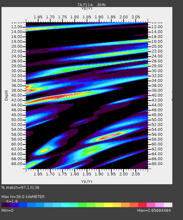
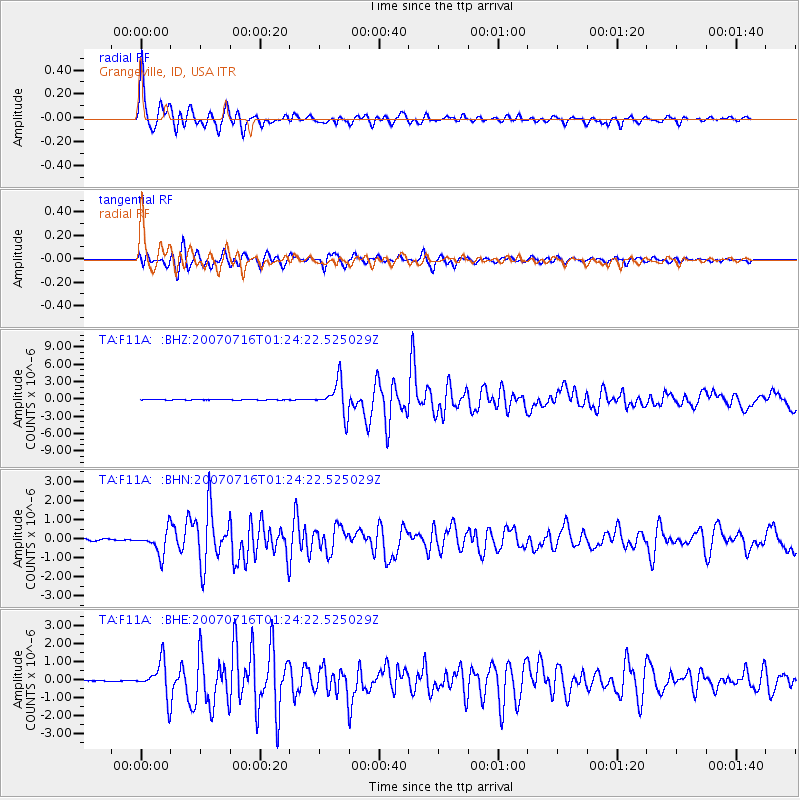
F11A Grangeville, ID, USA - Earthquake Result Viewer

Earthquake location: Near West Coast Of Honshu, Japan
Earthquake latitude/longitude: 37.5/138.4
Earthquake time(UTC): 2007/07/16 (197) 01:13:22 GMT
Earthquake Depth: 12 km
Earthquake Magnitude: 6.5 MB, 6.4 MS, 6.6 MW, 6.5 MW
Earthquake Catalog/Contributor: WHDF/NEIC
Network: TA USArray Transportable Network (new EarthScope stations)
Station: F11A Grangeville, ID, USA
Lat/Lon: 45.89 N/116.15 W
Elevation: 1186 m
Distance: 73.3 deg
Az: 44.66 deg
Baz: 306.87 deg
Ray Param: 0.053066444
Estimated Moho Depth: 38.0 km
Estimated Crust Vp/Vs: 1.60
Assumed Crust Vp: 6.571 km/s
Estimated Crust Vs: 4.107 km/s
Estimated Crust Poisson's Ratio: 0.18
Radial Match: 97.13136 %
Radial Bump: 400
Transverse Match: 93.35045 %
Transverse Bump: 400
SOD ConfigId: 2564
Insert Time: 2010-03-07 04:00:00.957 +0000
GWidth: 2.5
Max Bumps: 400
Tol: 0.001

Signal To Noise

ChannelStoNSTALTA
TA:F11A: :BHN:20070716T01:24:22.525029Z15.1309386.347954E-74.1953474E-8
TA:F11A: :BHE:20070716T01:24:22.525029Z24.8456889.5050615E-73.8256385E-8
TA:F11A: :BHZ:20070716T01:24:22.525029Z111.030282.7785873E-62.5025491E-8
Arrivals
Ps3.6 SECOND
PpPs14 SECOND
PsPs/PpSs18 SECOND