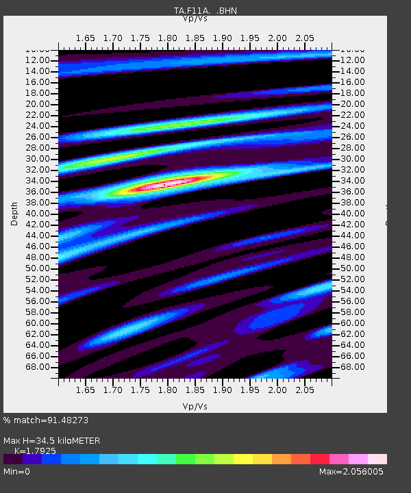
F11A Grangeville, ID, USA - Earthquake Result Viewer
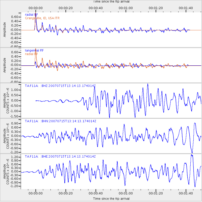
Earthquake location: Fox Islands, Aleutian Islands
Earthquake latitude/longitude: 52.5/-168.0
Earthquake time(UTC): 2007/07/15 (196) 13:08:00 GMT
Earthquake Depth: 10 km
Earthquake Magnitude: 5.8 MB, 5.9 MS, 6.1 MW, 6.0 MW
Earthquake Catalog/Contributor: WHDF/NEIC
Network: TA USArray Transportable Network (new EarthScope stations)
Station: F11A Grangeville, ID, USA
Lat/Lon: 45.89 N/116.15 W
Elevation: 1186 m
Distance: 33.9 deg
Az: 80.023 deg
Baz: 300.41 deg
Ray Param: 0.07798588
Estimated Moho Depth: 34.5 km
Estimated Crust Vp/Vs: 1.79
Assumed Crust Vp: 6.571 km/s
Estimated Crust Vs: 3.666 km/s
Estimated Crust Poisson's Ratio: 0.27
Radial Match: 91.48273 %
Radial Bump: 400
Transverse Match: 83.24436 %
Transverse Bump: 400
SOD ConfigId: 2564
Insert Time: 2010-03-07 04:00:02.644 +0000
GWidth: 2.5
Max Bumps: 400
Tol: 0.001

Signal To Noise

ChannelStoNSTALTA
TA:F11A: :BHN:20070715T13:14:13.174014Z2.5124631.0786596E-74.2932356E-8
TA:F11A: :BHE:20070715T13:14:13.174014Z4.26886941.5779176E-73.696336E-8
TA:F11A: :BHZ:20070715T13:14:13.174014Z5.61884263.359608E-75.9791816E-8
Arrivals
Ps4.5 SECOND
PpPs14 SECOND
PsPs/PpSs18 SECOND