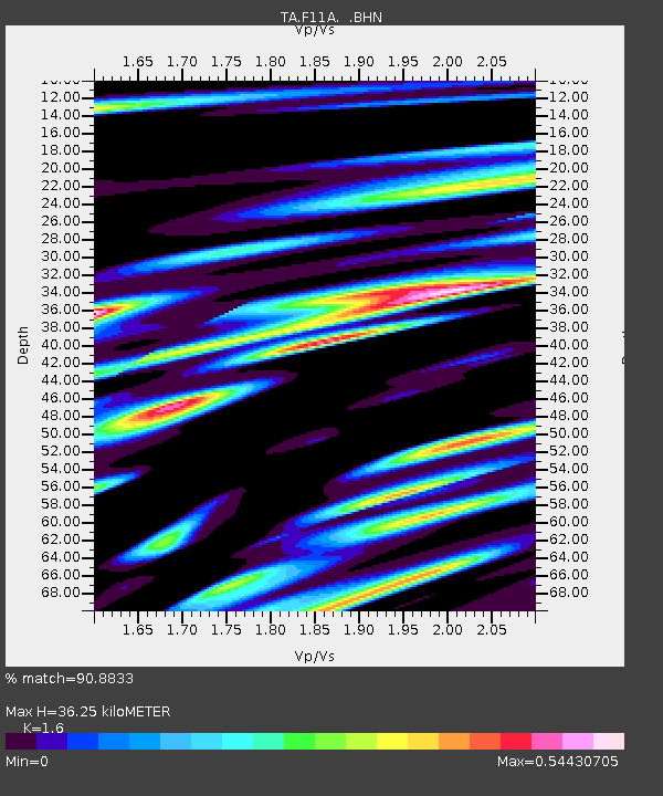
F11A Grangeville, ID, USA - Earthquake Result Viewer
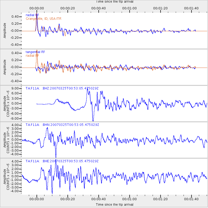
Earthquake location: Near West Coast Of Honshu, Japan
Earthquake latitude/longitude: 37.3/136.6
Earthquake time(UTC): 2007/03/25 (084) 00:41:57 GMT
Earthquake Depth: 8.0 km
Earthquake Magnitude: 6.1 MB, 6.8 MS, 6.7 MW, 6.6 MW
Earthquake Catalog/Contributor: WHDF/NEIC
Network: TA USArray Transportable Network (new EarthScope stations)
Station: F11A Grangeville, ID, USA
Lat/Lon: 45.89 N/116.15 W
Elevation: 1186 m
Distance: 74.5 deg
Az: 43.801 deg
Baz: 307.828 deg
Ray Param: 0.052287392
Estimated Moho Depth: 36.25 km
Estimated Crust Vp/Vs: 1.60
Assumed Crust Vp: 6.571 km/s
Estimated Crust Vs: 4.107 km/s
Estimated Crust Poisson's Ratio: 0.18
Radial Match: 90.8833 %
Radial Bump: 400
Transverse Match: 84.28991 %
Transverse Bump: 400
SOD ConfigId: 2564
Insert Time: 2010-03-07 04:00:09.404 +0000
GWidth: 2.5
Max Bumps: 400
Tol: 0.001

Signal To Noise

ChannelStoNSTALTA
TA:F11A: :BHN:20070325T00:53:05.475029Z6.53583571.1237926E-61.7194321E-7
TA:F11A: :BHE:20070325T00:53:05.475029Z2.9285871.3362034E-64.5626214E-7
TA:F11A: :BHZ:20070325T00:53:05.475029Z3.23941974.5358465E-61.4002035E-6
Arrivals
Ps3.4 SECOND
PpPs14 SECOND
PsPs/PpSs17 SECOND