You are here: Home > Network List > TA - USArray Transportable Network (new EarthScope stations) Stations List
> Station B18K Kokolik River, AK, USA > Earthquake Result Viewer
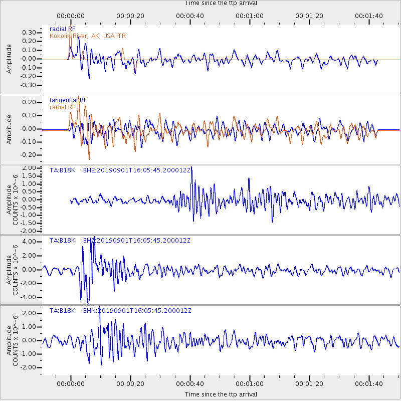
B18K Kokolik River, AK, USA - Earthquake Result Viewer
*The percent match for this event was below the threshold and hence no stack was calculated.
| Earthquake location: |
Fiji Islands Region |
| Earthquake latitude/longitude: |
-20.4/-178.4 |
| Earthquake time(UTC): |
2019/09/01 (244) 15:54:20 GMT |
| Earthquake Depth: |
617 km |
| Earthquake Magnitude: |
6.5 Mi |
| Earthquake Catalog/Contributor: |
NEIC PDE/at |
|
| Network: |
TA USArray Transportable Network (new EarthScope stations) |
| Station: |
B18K Kokolik River, AK, USA |
| Lat/Lon: |
69.36 N/161.80 W |
| Elevation: |
222 m |
|
| Distance: |
90.3 deg |
| Az: |
5.812 deg |
| Baz: |
195.543 deg |
| Ray Param: |
$rayparam |
*The percent match for this event was below the threshold and hence was not used in the summary stack. |
|
| Radial Match: |
76.33494 % |
| Radial Bump: |
400 |
| Transverse Match: |
72.34414 % |
| Transverse Bump: |
400 |
| SOD ConfigId: |
19053131 |
| Insert Time: |
2019-09-15 16:02:44.711 +0000 |
| GWidth: |
2.5 |
| Max Bumps: |
400 |
| Tol: |
0.001 |
|
Signal To Noise
| Channel | StoN | STA | LTA |
| TA:B18K: :BHZ:20190901T16:05:45.200012Z | 6.339711 | 1.5553411E-6 | 2.4533313E-7 |
| TA:B18K: :BHN:20190901T16:05:45.200012Z | 1.4105335 | 3.3438107E-7 | 2.3706E-7 |
| TA:B18K: :BHE:20190901T16:05:45.200012Z | 1.0741698 | 1.457622E-7 | 1.3569755E-7 |
| Arrivals |
| Ps | |
| PpPs | |
| PsPs/PpSs | |


