You are here: Home > Network List > TA - USArray Transportable Network (new EarthScope stations) Stations List
> Station C16K Lisburne Hills, AK, USA > Earthquake Result Viewer
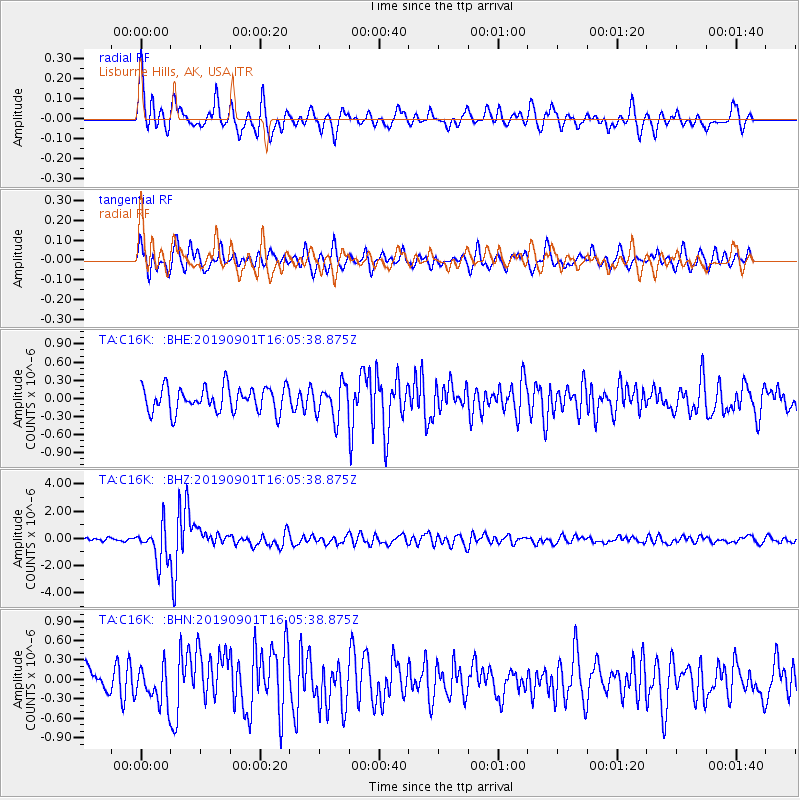
C16K Lisburne Hills, AK, USA - Earthquake Result Viewer
*The percent match for this event was below the threshold and hence no stack was calculated.
| Earthquake location: |
Fiji Islands Region |
| Earthquake latitude/longitude: |
-20.4/-178.4 |
| Earthquake time(UTC): |
2019/09/01 (244) 15:54:20 GMT |
| Earthquake Depth: |
617 km |
| Earthquake Magnitude: |
6.5 Mi |
| Earthquake Catalog/Contributor: |
NEIC PDE/at |
|
| Network: |
TA USArray Transportable Network (new EarthScope stations) |
| Station: |
C16K Lisburne Hills, AK, USA |
| Lat/Lon: |
68.27 N/165.34 W |
| Elevation: |
102 m |
|
| Distance: |
88.9 deg |
| Az: |
4.826 deg |
| Baz: |
192.237 deg |
| Ray Param: |
$rayparam |
*The percent match for this event was below the threshold and hence was not used in the summary stack. |
|
| Radial Match: |
78.373474 % |
| Radial Bump: |
388 |
| Transverse Match: |
71.41025 % |
| Transverse Bump: |
400 |
| SOD ConfigId: |
19053131 |
| Insert Time: |
2019-09-15 16:02:44.773 +0000 |
| GWidth: |
2.5 |
| Max Bumps: |
400 |
| Tol: |
0.001 |
|
Signal To Noise
| Channel | StoN | STA | LTA |
| TA:C16K: :BHZ:20190901T16:05:38.875Z | 7.15703 | 1.2941316E-6 | 1.8081964E-7 |
| TA:C16K: :BHN:20190901T16:05:38.875Z | 1.3484416 | 2.709195E-7 | 2.0091304E-7 |
| TA:C16K: :BHE:20190901T16:05:38.875Z | 1.3536351 | 2.768489E-7 | 2.0452258E-7 |
| Arrivals |
| Ps | |
| PpPs | |
| PsPs/PpSs | |


