You are here: Home > Network List > TA - USArray Transportable Network (new EarthScope stations) Stations List
> Station D22K Ayikyak River, AK, USA > Earthquake Result Viewer
D22K Ayikyak River, AK, USA - Earthquake Result Viewer
| Earthquake location: |
Fiji Islands Region |
| Earthquake latitude/longitude: |
-20.4/-178.4 |
| Earthquake time(UTC): |
2019/09/01 (244) 15:54:20 GMT |
| Earthquake Depth: |
617 km |
| Earthquake Magnitude: |
6.5 Mi |
| Earthquake Catalog/Contributor: |
NEIC PDE/at |
|
| Network: |
TA USArray Transportable Network (new EarthScope stations) |
| Station: |
D22K Ayikyak River, AK, USA |
| Lat/Lon: |
68.88 N/152.68 W |
| Elevation: |
532 m |
|
| Distance: |
91.0 deg |
| Az: |
9.05 deg |
| Baz: |
204.023 deg |
| Ray Param: |
0.04127859 |
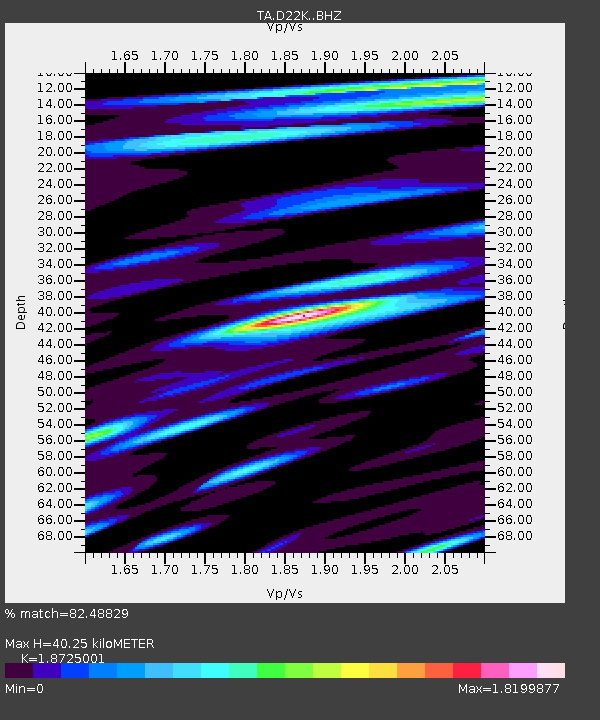
| Estimated Moho Depth: |
40.25 km |
| Estimated Crust Vp/Vs: |
1.87 |
| Assumed Crust Vp: |
6.221 km/s |
| Estimated Crust Vs: |
3.322 km/s |
| Estimated Crust Poisson's Ratio: |
0.30 |
|
| Radial Match: |
82.48829 % |
| Radial Bump: |
400 |
| Transverse Match: |
76.52253 % |
| Transverse Bump: |
400 |
| SOD ConfigId: |
19053131 |
| Insert Time: |
2019-09-15 16:02:52.546 +0000 |
| GWidth: |
2.5 |
| Max Bumps: |
400 |
| Tol: |
0.001 |
|

Signal To Noise
| Channel | StoN | STA | LTA |
| TA:D22K: :BHZ:20190901T16:05:48.174988Z | 6.392521 | 1.2098983E-6 | 1.892678E-7 |
| TA:D22K: :BHN:20190901T16:05:48.174988Z | 1.9269482 | 2.711066E-7 | 1.4069221E-7 |
| TA:D22K: :BHE:20190901T16:05:48.174988Z | 2.0921695 | 3.0122473E-7 | 1.4397722E-7 |
| Arrivals |
| Ps | 5.7 SECOND |
| PpPs | 18 SECOND |
| PsPs/PpSs | 24 SECOND |


