You are here: Home > Network List > TA - USArray Transportable Network (new EarthScope stations) Stations List
> Station E18K Tukpahlearik Creek, AK, USA > Earthquake Result Viewer
E18K Tukpahlearik Creek, AK, USA - Earthquake Result Viewer

| Earthquake location: |
Fiji Islands Region |
| Earthquake latitude/longitude: |
-20.4/-178.4 |
| Earthquake time(UTC): |
2019/09/01 (244) 15:54:20 GMT |
| Earthquake Depth: |
617 km |
| Earthquake Magnitude: |
6.5 Mi |
| Earthquake Catalog/Contributor: |
NEIC PDE/at |
|
| Network: |
TA USArray Transportable Network (new EarthScope stations) |
| Station: |
E18K Tukpahlearik Creek, AK, USA |
| Lat/Lon: |
67.42 N/160.60 W |
| Elevation: |
297 m |
|
| Distance: |
88.6 deg |
| Az: |
6.78 deg |
| Baz: |
196.667 deg |
| Ray Param: |
0.041635383 |
| Estimated Moho Depth: |
50.75 km |
| Estimated Crust Vp/Vs: |
2.00 |
| Assumed Crust Vp: |
6.276 km/s |
| Estimated Crust Vs: |
3.146 km/s |
| Estimated Crust Poisson's Ratio: |
0.33 |
|
| Radial Match: |
91.28886 % |
| Radial Bump: |
400 |
| Transverse Match: |
83.059616 % |
| Transverse Bump: |
400 |
| SOD ConfigId: |
19053131 |
| Insert Time: |
2019-09-15 16:02:56.285 +0000 |
| GWidth: |
2.5 |
| Max Bumps: |
400 |
| Tol: |
0.001 |
|
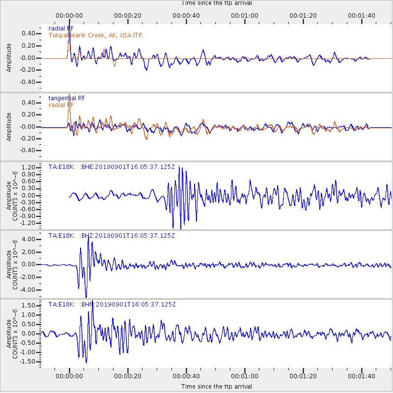
Signal To Noise
| Channel | StoN | STA | LTA |
| TA:E18K: :BHZ:20190901T16:05:37.125Z | 14.873956 | 1.2546124E-6 | 8.4349615E-8 |
| TA:E18K: :BHN:20190901T16:05:37.125Z | 7.6363244 | 5.27805E-7 | 6.9117675E-8 |
| TA:E18K: :BHE:20190901T16:05:37.125Z | 3.2168188 | 2.9011986E-7 | 9.0188436E-8 |
| Arrivals |
| Ps | 8.2 SECOND |
| PpPs | 24 SECOND |
| PsPs/PpSs | 32 SECOND |


