You are here: Home > Network List > TA - USArray Transportable Network (new EarthScope stations) Stations List
> Station E27K Coleen River, AK, USA > Earthquake Result Viewer
E27K Coleen River, AK, USA - Earthquake Result Viewer
| Earthquake location: |
Fiji Islands Region |
| Earthquake latitude/longitude: |
-20.4/-178.4 |
| Earthquake time(UTC): |
2019/09/01 (244) 15:54:20 GMT |
| Earthquake Depth: |
617 km |
| Earthquake Magnitude: |
6.5 Mi |
| Earthquake Catalog/Contributor: |
NEIC PDE/at |
|
| Network: |
TA USArray Transportable Network (new EarthScope stations) |
| Station: |
E27K Coleen River, AK, USA |
| Lat/Lon: |
68.19 N/141.60 W |
| Elevation: |
654 m |
|
| Distance: |
92.3 deg |
| Az: |
12.95 deg |
| Baz: |
214.225 deg |
| Ray Param: |
0.040977053 |
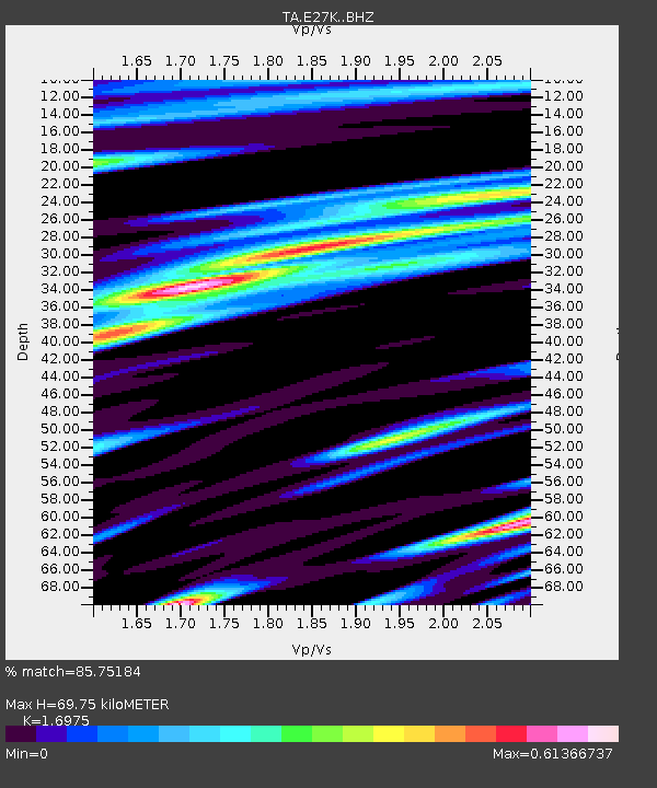
| Estimated Moho Depth: |
69.75 km |
| Estimated Crust Vp/Vs: |
1.70 |
| Assumed Crust Vp: |
6.522 km/s |
| Estimated Crust Vs: |
3.842 km/s |
| Estimated Crust Poisson's Ratio: |
0.23 |
|
| Radial Match: |
85.75184 % |
| Radial Bump: |
400 |
| Transverse Match: |
71.34629 % |
| Transverse Bump: |
400 |
| SOD ConfigId: |
19053131 |
| Insert Time: |
2019-09-15 16:03:01.924 +0000 |
| GWidth: |
2.5 |
| Max Bumps: |
400 |
| Tol: |
0.001 |
|

Signal To Noise
| Channel | StoN | STA | LTA |
| TA:E27K: :BHZ:20190901T16:05:54.474976Z | 7.8262196 | 6.81273E-7 | 8.705007E-8 |
| TA:E27K: :BHN:20190901T16:05:54.474976Z | 1.8941269 | 1.7500746E-7 | 9.239479E-8 |
| TA:E27K: :BHE:20190901T16:05:54.474976Z | 2.788213 | 1.5903866E-7 | 5.703964E-8 |
| Arrivals |
| Ps | 7.6 SECOND |
| PpPs | 28 SECOND |
| PsPs/PpSs | 36 SECOND |


