You are here: Home > Network List > TA - USArray Transportable Network (new EarthScope stations) Stations List
> Station F26K Sheenjek River, AK, USA > Earthquake Result Viewer
F26K Sheenjek River, AK, USA - Earthquake Result Viewer
| Earthquake location: |
Fiji Islands Region |
| Earthquake latitude/longitude: |
-20.4/-178.4 |
| Earthquake time(UTC): |
2019/09/01 (244) 15:54:20 GMT |
| Earthquake Depth: |
617 km |
| Earthquake Magnitude: |
6.5 Mi |
| Earthquake Catalog/Contributor: |
NEIC PDE/at |
|
| Network: |
TA USArray Transportable Network (new EarthScope stations) |
| Station: |
F26K Sheenjek River, AK, USA |
| Lat/Lon: |
67.69 N/144.15 W |
| Elevation: |
683 m |
|
| Distance: |
91.4 deg |
| Az: |
12.411 deg |
| Baz: |
211.881 deg |
| Ray Param: |
0.041193027 |
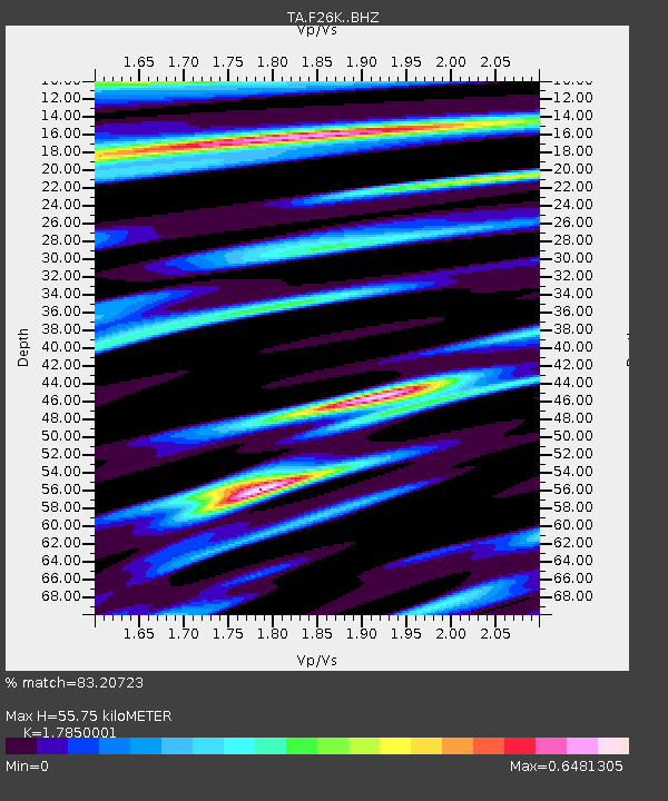
| Estimated Moho Depth: |
55.75 km |
| Estimated Crust Vp/Vs: |
1.79 |
| Assumed Crust Vp: |
6.522 km/s |
| Estimated Crust Vs: |
3.654 km/s |
| Estimated Crust Poisson's Ratio: |
0.27 |
|
| Radial Match: |
83.20723 % |
| Radial Bump: |
400 |
| Transverse Match: |
78.45762 % |
| Transverse Bump: |
400 |
| SOD ConfigId: |
19053131 |
| Insert Time: |
2019-09-15 16:03:09.773 +0000 |
| GWidth: |
2.5 |
| Max Bumps: |
400 |
| Tol: |
0.001 |
|

Signal To Noise
| Channel | StoN | STA | LTA |
| TA:F26K: :BHZ:20190901T16:05:50.200012Z | 4.9662957 | 6.543846E-7 | 1.3176513E-7 |
| TA:F26K: :BHN:20190901T16:05:50.200012Z | 1.2370286 | 1.1042475E-7 | 8.926612E-8 |
| TA:F26K: :BHE:20190901T16:05:50.200012Z | 0.89042896 | 6.183747E-8 | 6.944683E-8 |
| Arrivals |
| Ps | 6.9 SECOND |
| PpPs | 23 SECOND |
| PsPs/PpSs | 30 SECOND |


