You are here: Home > Network List > TA - USArray Transportable Network (new EarthScope stations) Stations List
> Station J18K Innoko River, AK, USA > Earthquake Result Viewer
J18K Innoko River, AK, USA - Earthquake Result Viewer
| Earthquake location: |
Fiji Islands Region |
| Earthquake latitude/longitude: |
-20.4/-178.4 |
| Earthquake time(UTC): |
2019/09/01 (244) 15:54:20 GMT |
| Earthquake Depth: |
617 km |
| Earthquake Magnitude: |
6.5 Mi |
| Earthquake Catalog/Contributor: |
NEIC PDE/at |
|
| Network: |
TA USArray Transportable Network (new EarthScope stations) |
| Station: |
J18K Innoko River, AK, USA |
| Lat/Lon: |
63.47 N/156.72 W |
| Elevation: |
506 m |
|
| Distance: |
85.3 deg |
| Az: |
9.585 deg |
| Baz: |
200.351 deg |
| Ray Param: |
0.043047447 |
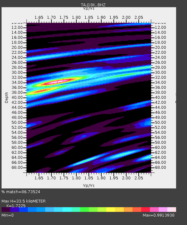
| Estimated Moho Depth: |
33.5 km |
| Estimated Crust Vp/Vs: |
1.72 |
| Assumed Crust Vp: |
6.182 km/s |
| Estimated Crust Vs: |
3.589 km/s |
| Estimated Crust Poisson's Ratio: |
0.25 |
|
| Radial Match: |
86.73524 % |
| Radial Bump: |
280 |
| Transverse Match: |
75.44319 % |
| Transverse Bump: |
354 |
| SOD ConfigId: |
19053131 |
| Insert Time: |
2019-09-15 16:03:34.451 +0000 |
| GWidth: |
2.5 |
| Max Bumps: |
400 |
| Tol: |
0.001 |
|

Signal To Noise
| Channel | StoN | STA | LTA |
| TA:J18K: :BHZ:20190901T16:05:21.924988Z | 18.52948 | 1.8737333E-6 | 1.01121735E-7 |
| TA:J18K: :BHN:20190901T16:05:21.924988Z | 5.3990736 | 6.027061E-7 | 1.116314E-7 |
| TA:J18K: :BHE:20190901T16:05:21.924988Z | 2.4758246 | 4.1053747E-7 | 1.6581848E-7 |
| Arrivals |
| Ps | 4.0 SECOND |
| PpPs | 14 SECOND |
| PsPs/PpSs | 18 SECOND |


