You are here: Home > Network List > TA - USArray Transportable Network (new EarthScope stations) Stations List
> Station L15K Ungalak Mountain, AK, USA > Earthquake Result Viewer
L15K Ungalak Mountain, AK, USA - Earthquake Result Viewer
| Earthquake location: |
Fiji Islands Region |
| Earthquake latitude/longitude: |
-20.4/-178.4 |
| Earthquake time(UTC): |
2019/09/01 (244) 15:54:20 GMT |
| Earthquake Depth: |
617 km |
| Earthquake Magnitude: |
6.5 Mi |
| Earthquake Catalog/Contributor: |
NEIC PDE/at |
|
| Network: |
TA USArray Transportable Network (new EarthScope stations) |
| Station: |
L15K Ungalak Mountain, AK, USA |
| Lat/Lon: |
61.68 N/161.49 W |
| Elevation: |
219 m |
|
| Distance: |
82.9 deg |
| Az: |
8.037 deg |
| Baz: |
195.962 deg |
| Ray Param: |
0.04468889 |
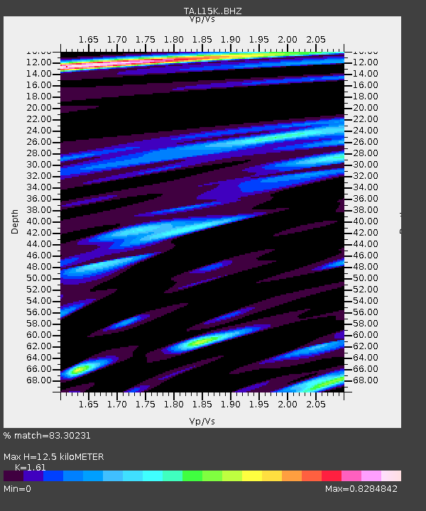
| Estimated Moho Depth: |
12.5 km |
| Estimated Crust Vp/Vs: |
1.61 |
| Assumed Crust Vp: |
6.182 km/s |
| Estimated Crust Vs: |
3.84 km/s |
| Estimated Crust Poisson's Ratio: |
0.19 |
|
| Radial Match: |
83.30231 % |
| Radial Bump: |
400 |
| Transverse Match: |
79.81981 % |
| Transverse Bump: |
400 |
| SOD ConfigId: |
19053131 |
| Insert Time: |
2019-09-15 16:03:45.024 +0000 |
| GWidth: |
2.5 |
| Max Bumps: |
400 |
| Tol: |
0.001 |
|

Signal To Noise
| Channel | StoN | STA | LTA |
| TA:L15K: :BHZ:20190901T16:05:10.275024Z | 14.303293 | 2.4170272E-6 | 1.6898396E-7 |
| TA:L15K: :BHN:20190901T16:05:10.275024Z | 4.1602235 | 8.21716E-7 | 1.9751728E-7 |
| TA:L15K: :BHE:20190901T16:05:10.275024Z | 1.4054803 | 3.5092228E-7 | 2.496814E-7 |
| Arrivals |
| Ps | 1.3 SECOND |
| PpPs | 5.2 SECOND |
| PsPs/PpSs | 6.4 SECOND |


