You are here: Home > Network List > TA - USArray Transportable Network (new EarthScope stations) Stations List
> Station L17K Donlin, AK, USA > Earthquake Result Viewer
L17K Donlin, AK, USA - Earthquake Result Viewer
| Earthquake location: |
Fiji Islands Region |
| Earthquake latitude/longitude: |
-20.4/-178.4 |
| Earthquake time(UTC): |
2019/09/01 (244) 15:54:20 GMT |
| Earthquake Depth: |
617 km |
| Earthquake Magnitude: |
6.5 Mi |
| Earthquake Catalog/Contributor: |
NEIC PDE/at |
|
| Network: |
TA USArray Transportable Network (new EarthScope stations) |
| Station: |
L17K Donlin, AK, USA |
| Lat/Lon: |
62.13 N/158.30 W |
| Elevation: |
338 m |
|
| Distance: |
83.8 deg |
| Az: |
9.349 deg |
| Baz: |
198.924 deg |
| Ray Param: |
0.044086512 |
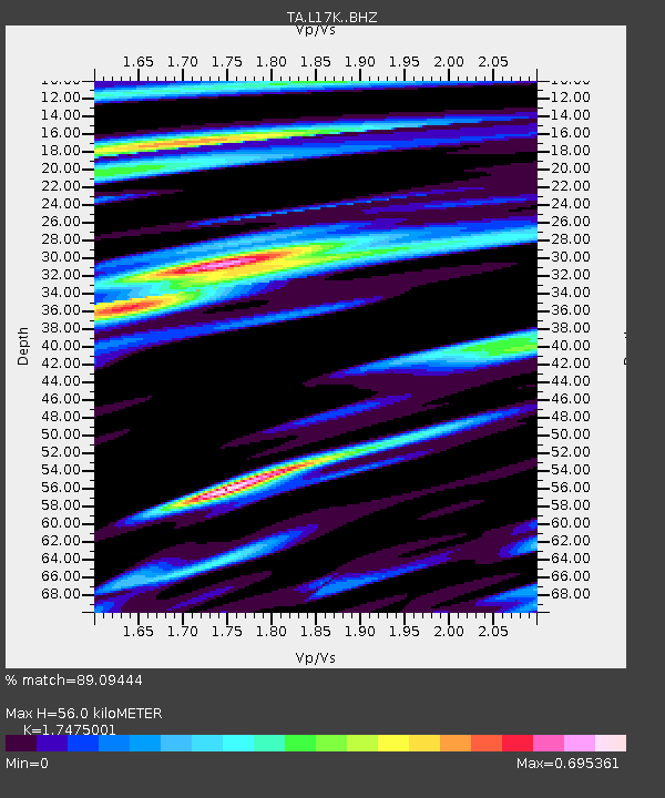
| Estimated Moho Depth: |
56.0 km |
| Estimated Crust Vp/Vs: |
1.75 |
| Assumed Crust Vp: |
6.276 km/s |
| Estimated Crust Vs: |
3.591 km/s |
| Estimated Crust Poisson's Ratio: |
0.26 |
|
| Radial Match: |
89.09444 % |
| Radial Bump: |
400 |
| Transverse Match: |
86.30365 % |
| Transverse Bump: |
400 |
| SOD ConfigId: |
19053131 |
| Insert Time: |
2019-09-15 16:03:45.302 +0000 |
| GWidth: |
2.5 |
| Max Bumps: |
400 |
| Tol: |
0.001 |
|

Signal To Noise
| Channel | StoN | STA | LTA |
| TA:L17K: :BHZ:20190901T16:05:14.674988Z | 7.6864853 | 2.1699307E-6 | 2.8230465E-7 |
| TA:L17K: :BHN:20190901T16:05:14.674988Z | 3.1098409 | 6.2780464E-7 | 2.0187677E-7 |
| TA:L17K: :BHE:20190901T16:05:14.674988Z | 1.4584057 | 3.5766706E-7 | 2.4524522E-7 |
| Arrivals |
| Ps | 6.8 SECOND |
| PpPs | 24 SECOND |
| PsPs/PpSs | 31 SECOND |


