You are here: Home > Network List > TA - USArray Transportable Network (new EarthScope stations) Stations List
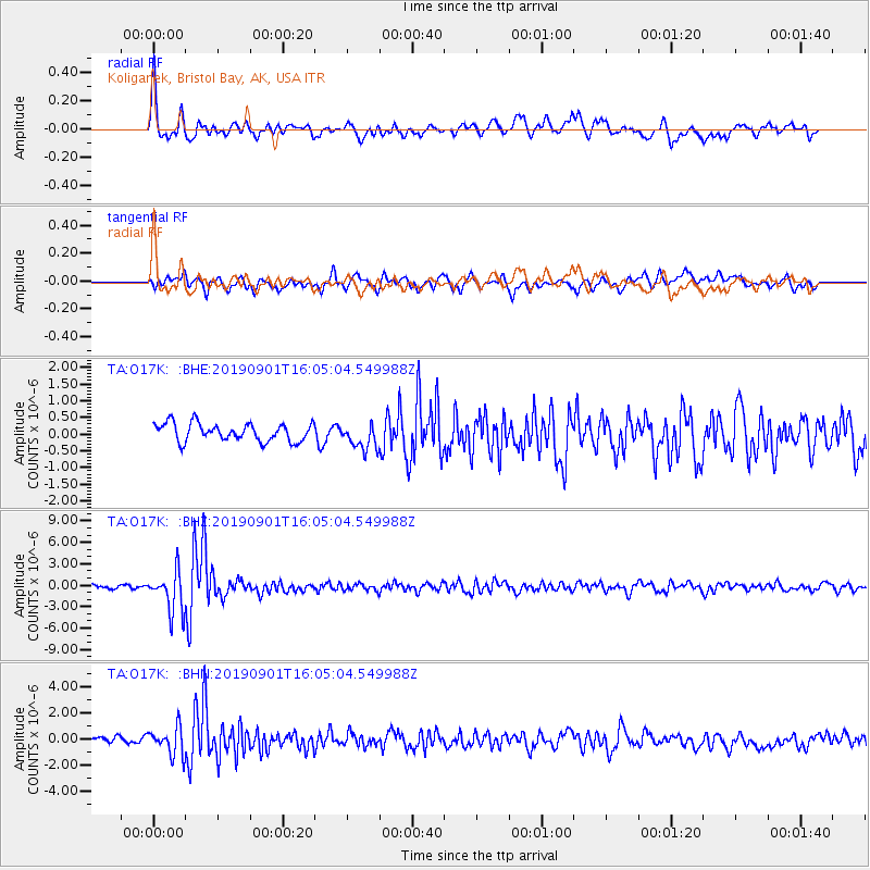
> Station O17K Koliganek, Bristol Bay, AK, USA > Earthquake Result Viewer
O17K Koliganek, Bristol Bay, AK, USA - Earthquake Result Viewer
| Earthquake location: |
Fiji Islands Region |
| Earthquake latitude/longitude: |
-20.4/-178.4 |
| Earthquake time(UTC): |
2019/09/01 (244) 15:54:20 GMT |
| Earthquake Depth: |
617 km |
| Earthquake Magnitude: |
6.5 Mi |
| Earthquake Catalog/Contributor: |
NEIC PDE/at |
|
| Network: |
TA USArray Transportable Network (new EarthScope stations) |
| Station: |
O17K Koliganek, Bristol Bay, AK, USA |
| Lat/Lon: |
59.77 N/157.09 W |
| Elevation: |
156 m |
|
| Distance: |
81.8 deg |
| Az: |
10.705 deg |
| Baz: |
200.144 deg |
| Ray Param: |
0.04547263 |
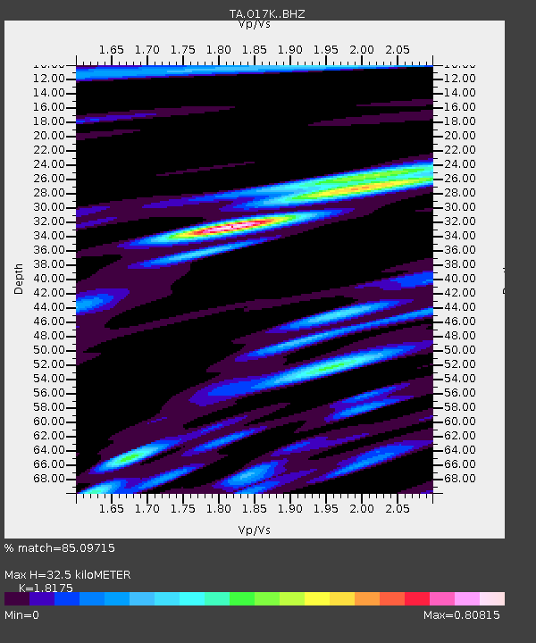
| Estimated Moho Depth: |
32.5 km |
| Estimated Crust Vp/Vs: |
1.82 |
| Assumed Crust Vp: |
6.276 km/s |
| Estimated Crust Vs: |
3.453 km/s |
| Estimated Crust Poisson's Ratio: |
0.28 |
|
| Radial Match: |
85.09715 % |
| Radial Bump: |
400 |
| Transverse Match: |
73.18573 % |
| Transverse Bump: |
400 |
| SOD ConfigId: |
19053131 |
| Insert Time: |
2019-09-15 16:04:07.476 +0000 |
| GWidth: |
2.5 |
| Max Bumps: |
400 |
| Tol: |
0.001 |
|
Signal To Noise
| Channel | StoN | STA | LTA |
| TA:O17K: :BHZ:20190901T16:05:04.549988Z | 10.952468 | 2.860737E-6 | 2.6119565E-7 |
| TA:O17K: :BHN:20190901T16:05:04.549988Z | 3.0877686 | 1.0632078E-6 | 3.4432887E-7 |
| TA:O17K: :BHE:20190901T16:05:04.549988Z | 1.4698935 | 3.9223303E-7 | 2.6684452E-7 |
| Arrivals |
| Ps | 4.3 SECOND |
| PpPs | 14 SECOND |
| PsPs/PpSs | 19 SECOND |


