You are here: Home > Network List > TA - USArray Transportable Network (new EarthScope stations) Stations List
> Station S31K Pelican, AK, USA > Earthquake Result Viewer
S31K Pelican, AK, USA - Earthquake Result Viewer
| Earthquake location: |
Fiji Islands Region |
| Earthquake latitude/longitude: |
-20.4/-178.4 |
| Earthquake time(UTC): |
2019/09/01 (244) 15:54:20 GMT |
| Earthquake Depth: |
617 km |
| Earthquake Magnitude: |
6.5 Mi |
| Earthquake Catalog/Contributor: |
NEIC PDE/at |
|
| Network: |
TA USArray Transportable Network (new EarthScope stations) |
| Station: |
S31K Pelican, AK, USA |
| Lat/Lon: |
57.96 N/136.23 W |
| Elevation: |
34 m |
|
| Distance: |
85.6 deg |
| Az: |
21.034 deg |
| Baz: |
219.169 deg |
| Ray Param: |
0.0428654 |
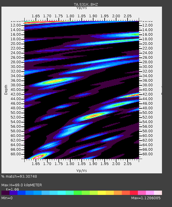
| Estimated Moho Depth: |
69.0 km |
| Estimated Crust Vp/Vs: |
1.66 |
| Assumed Crust Vp: |
6.134 km/s |
| Estimated Crust Vs: |
3.695 km/s |
| Estimated Crust Poisson's Ratio: |
0.22 |
|
| Radial Match: |
93.30748 % |
| Radial Bump: |
400 |
| Transverse Match: |
88.17919 % |
| Transverse Bump: |
400 |
| SOD ConfigId: |
19053131 |
| Insert Time: |
2019-09-15 16:04:23.148 +0000 |
| GWidth: |
2.5 |
| Max Bumps: |
400 |
| Tol: |
0.001 |
|

Signal To Noise
| Channel | StoN | STA | LTA |
| TA:S31K: :BHZ:20190901T16:05:23.150024Z | 19.18035 | 1.282531E-6 | 6.686693E-8 |
| TA:S31K: :BHN:20190901T16:05:23.150024Z | 5.452711 | 4.200072E-7 | 7.7027224E-8 |
| TA:S31K: :BHE:20190901T16:05:23.150024Z | 6.960325 | 3.1539008E-7 | 4.531255E-8 |
| Arrivals |
| Ps | 7.6 SECOND |
| PpPs | 29 SECOND |
| PsPs/PpSs | 37 SECOND |


