You are here: Home > Network List > US - United States National Seismic Network Stations List
> Station WRAK Wrangell Island, Southeastern Alaska, Alaska, USA > Earthquake Result Viewer
WRAK Wrangell Island, Southeastern Alaska, Alaska, USA - Earthquake Result Viewer

| Earthquake location: |
Fiji Islands Region |
| Earthquake latitude/longitude: |
-20.4/-178.4 |
| Earthquake time(UTC): |
2019/09/01 (244) 15:54:20 GMT |
| Earthquake Depth: |
617 km |
| Earthquake Magnitude: |
6.5 Mi |
| Earthquake Catalog/Contributor: |
NEIC PDE/at |
|
| Network: |
US United States National Seismic Network |
| Station: |
WRAK Wrangell Island, Southeastern Alaska, Alaska, USA |
| Lat/Lon: |
56.42 N/132.35 W |
| Elevation: |
81 m |
|
| Distance: |
85.8 deg |
| Az: |
23.652 deg |
| Baz: |
222.627 deg |
| Ray Param: |
0.04271262 |
| Estimated Moho Depth: |
61.25 km |
| Estimated Crust Vp/Vs: |
2.00 |
| Assumed Crust Vp: |
6.597 km/s |
| Estimated Crust Vs: |
3.299 km/s |
| Estimated Crust Poisson's Ratio: |
0.33 |
|
| Radial Match: |
90.7313 % |
| Radial Bump: |
400 |
| Transverse Match: |
81.38792 % |
| Transverse Bump: |
400 |
| SOD ConfigId: |
19053131 |
| Insert Time: |
2019-09-15 16:05:12.554 +0000 |
| GWidth: |
2.5 |
| Max Bumps: |
400 |
| Tol: |
0.001 |
|
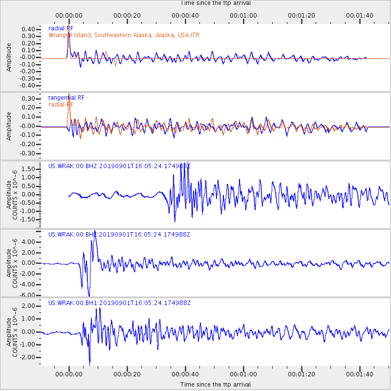
Signal To Noise
| Channel | StoN | STA | LTA |
| US:WRAK:00:BHZ:20190901T16:05:24.174988Z | 12.004943 | 1.2263944E-6 | 1.0215745E-7 |
| US:WRAK:00:BH1:20190901T16:05:24.174988Z | 2.5247383 | 2.5453375E-7 | 1.0081589E-7 |
| US:WRAK:00:BH2:20190901T16:05:24.174988Z | 3.0823119 | 3.13722E-7 | 1.01781396E-7 |
| Arrivals |
| Ps | 9.5 SECOND |
| PpPs | 27 SECOND |
| PsPs/PpSs | 37 SECOND |


