You are here: Home > Network List > UU - University of Utah Regional Network Stations List
> Station SVWY Solvay Mine, WY, USA > Earthquake Result Viewer
SVWY Solvay Mine, WY, USA - Earthquake Result Viewer
| Earthquake location: |
Fiji Islands Region |
| Earthquake latitude/longitude: |
-20.4/-178.4 |
| Earthquake time(UTC): |
2019/09/01 (244) 15:54:20 GMT |
| Earthquake Depth: |
617 km |
| Earthquake Magnitude: |
6.5 Mi |
| Earthquake Catalog/Contributor: |
NEIC PDE/at |
|
| Network: |
UU University of Utah Regional Network |
| Station: |
SVWY Solvay Mine, WY, USA |
| Lat/Lon: |
41.45 N/109.86 W |
| Elevation: |
1950 m |
|
| Distance: |
88.3 deg |
| Az: |
44.419 deg |
| Baz: |
240.852 deg |
| Ray Param: |
0.04165273 |
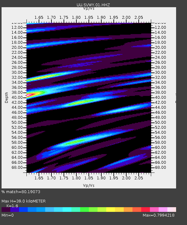
| Estimated Moho Depth: |
39.0 km |
| Estimated Crust Vp/Vs: |
1.60 |
| Assumed Crust Vp: |
6.207 km/s |
| Estimated Crust Vs: |
3.879 km/s |
| Estimated Crust Poisson's Ratio: |
0.18 |
|
| Radial Match: |
80.19073 % |
| Radial Bump: |
400 |
| Transverse Match: |
78.1215 % |
| Transverse Bump: |
384 |
| SOD ConfigId: |
19053131 |
| Insert Time: |
2019-09-15 16:05:20.749 +0000 |
| GWidth: |
2.5 |
| Max Bumps: |
400 |
| Tol: |
0.001 |
|

Signal To Noise
| Channel | StoN | STA | LTA |
| UU:SVWY:01:HHZ:20190901T16:05:35.98999Z | 2.2392495 | 9.761094E-9 | 4.3590918E-9 |
| UU:SVWY:01:HHN:20190901T16:05:35.98999Z | 1.5406708 | 6.0115783E-9 | 3.901923E-9 |
| UU:SVWY:01:HHE:20190901T16:05:35.98999Z | 0.704087 | 3.1730107E-9 | 4.5065605E-9 |
| Arrivals |
| Ps | 3.9 SECOND |
| PpPs | 16 SECOND |
| PsPs/PpSs | 20 SECOND |


