You are here: Home > Network List > UW - Pacific Northwest Regional Seismic Network Stations List
> Station BERY Pilchuck Tree Farm, Arlington, WA, USA > Earthquake Result Viewer
BERY Pilchuck Tree Farm, Arlington, WA, USA - Earthquake Result Viewer
| Earthquake location: |
Fiji Islands Region |
| Earthquake latitude/longitude: |
-20.4/-178.4 |
| Earthquake time(UTC): |
2019/09/01 (244) 15:54:20 GMT |
| Earthquake Depth: |
617 km |
| Earthquake Magnitude: |
6.5 Mi |
| Earthquake Catalog/Contributor: |
NEIC PDE/at |
|
| Network: |
UW Pacific Northwest Regional Seismic Network |
| Station: |
BERY Pilchuck Tree Farm, Arlington, WA, USA |
| Lat/Lon: |
48.26 N/122.10 W |
| Elevation: |
150 m |
|
| Distance: |
84.8 deg |
| Az: |
33.93 deg |
| Baz: |
231.593 deg |
| Ray Param: |
0.043366566 |
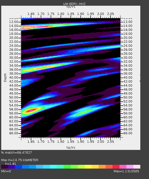
| Estimated Moho Depth: |
14.75 km |
| Estimated Crust Vp/Vs: |
1.61 |
| Assumed Crust Vp: |
6.566 km/s |
| Estimated Crust Vs: |
4.078 km/s |
| Estimated Crust Poisson's Ratio: |
0.19 |
|
| Radial Match: |
86.47827 % |
| Radial Bump: |
400 |
| Transverse Match: |
73.274155 % |
| Transverse Bump: |
400 |
| SOD ConfigId: |
19053131 |
| Insert Time: |
2019-09-15 16:05:24.218 +0000 |
| GWidth: |
2.5 |
| Max Bumps: |
400 |
| Tol: |
0.001 |
|

Signal To Noise
| Channel | StoN | STA | LTA |
| UW:BERY: :HHZ:20190901T16:05:19.710022Z | 9.4284 | 8.266116E-7 | 8.767251E-8 |
| UW:BERY: :HHN:20190901T16:05:19.710022Z | 3.2868674 | 2.3020635E-7 | 7.003822E-8 |
| UW:BERY: :HHE:20190901T16:05:19.710022Z | 1.8647145 | 1.4516064E-7 | 7.784604E-8 |
| Arrivals |
| Ps | 1.4 SECOND |
| PpPs | 5.7 SECOND |
| PsPs/PpSs | 7.1 SECOND |


