You are here: Home > Network List > TS - TERRAscope (Southern California Seismic Network) Stations List
> Station MLAC Mammoth Lakes, California, USA > Earthquake Result Viewer
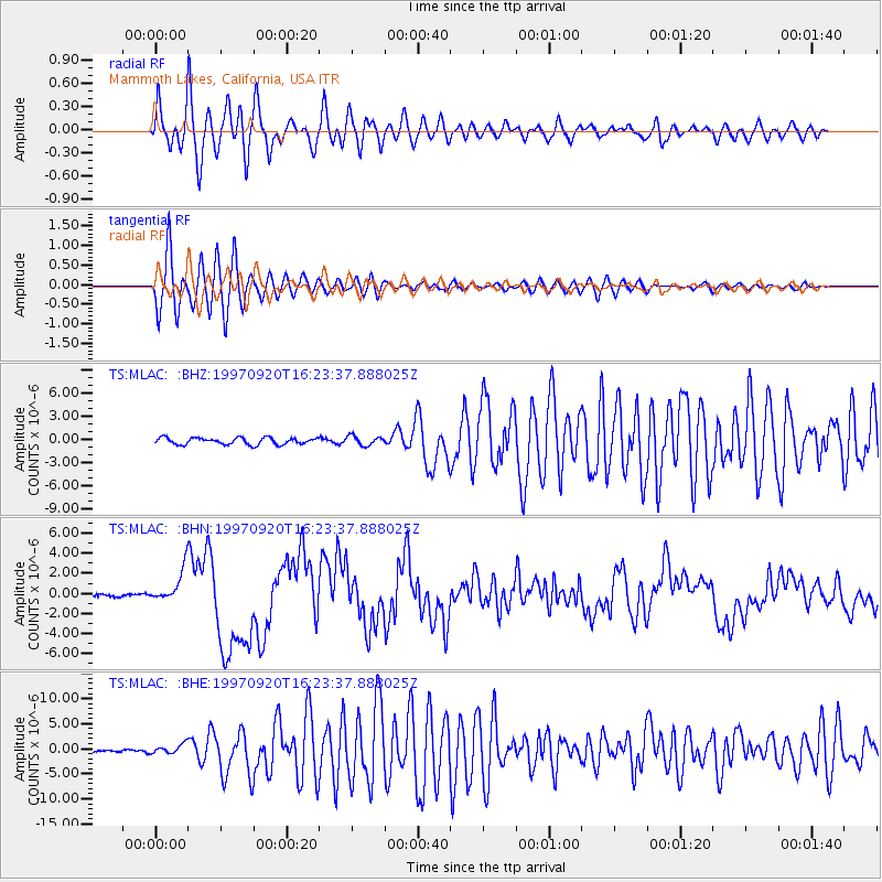
MLAC Mammoth Lakes, California, USA - Earthquake Result Viewer
*The percent match for this event was below the threshold and hence no stack was calculated.
| Earthquake location: |
Kermadec Islands Region |
| Earthquake latitude/longitude: |
-28.7/-177.6 |
| Earthquake time(UTC): |
1997/09/20 (263) 16:11:32 GMT |
| Earthquake Depth: |
30 km |
| Earthquake Magnitude: |
6.1 MB, 7.0 MS, 7.2 UNKNOWN, 6.7 ME |
| Earthquake Catalog/Contributor: |
WHDF/NEIC |
|
| Network: |
TS TERRAscope (Southern California Seismic Network) |
| Station: |
MLAC Mammoth Lakes, California, USA |
| Lat/Lon: |
37.63 N/118.83 W |
| Elevation: |
2170 m |
|
| Distance: |
85.9 deg |
| Az: |
42.903 deg |
| Baz: |
228.885 deg |
| Ray Param: |
$rayparam |
*The percent match for this event was below the threshold and hence was not used in the summary stack. |
|
| Radial Match: |
82.92078 % |
| Radial Bump: |
400 |
| Transverse Match: |
88.794266 % |
| Transverse Bump: |
400 |
| SOD ConfigId: |
4480 |
| Insert Time: |
2010-02-26 14:27:59.508 +0000 |
| GWidth: |
2.5 |
| Max Bumps: |
400 |
| Tol: |
0.001 |
|
Signal To Noise
| Channel | StoN | STA | LTA |
| TS:MLAC: :BHN:19970920T16:23:37.888025Z | 16.719069 | 1.6921612E-6 | 1.0121145E-7 |
| TS:MLAC: :BHE:19970920T16:23:37.888025Z | 3.6145437 | 9.667509E-7 | 2.674614E-7 |
| TS:MLAC: :BHZ:19970920T16:23:37.888025Z | 1.3946465 | 6.09821E-7 | 4.3725845E-7 |
| Arrivals |
| Ps | |
| PpPs | |
| PsPs/PpSs | |


