You are here: Home > Network List > CN - Canadian National Seismograph Network Stations List
> Station CBB Campbell River, BC, CA > Earthquake Result Viewer
CBB Campbell River, BC, CA - Earthquake Result Viewer
| Earthquake location: |
Northern Mid-Atlantic Ridge |
| Earthquake latitude/longitude: |
23.8/-45.2 |
| Earthquake time(UTC): |
2019/09/02 (245) 22:45:48 GMT |
| Earthquake Depth: |
10 km |
| Earthquake Magnitude: |
5.9 Mww |
| Earthquake Catalog/Contributor: |
NEIC PDE/us |
|
| Network: |
CN Canadian National Seismograph Network |
| Station: |
CBB Campbell River, BC, CA |
| Lat/Lon: |
50.03 N/125.37 W |
| Elevation: |
277 m |
|
| Distance: |
66.0 deg |
| Az: |
315.919 deg |
| Baz: |
81.278 deg |
| Ray Param: |
0.057921108 |
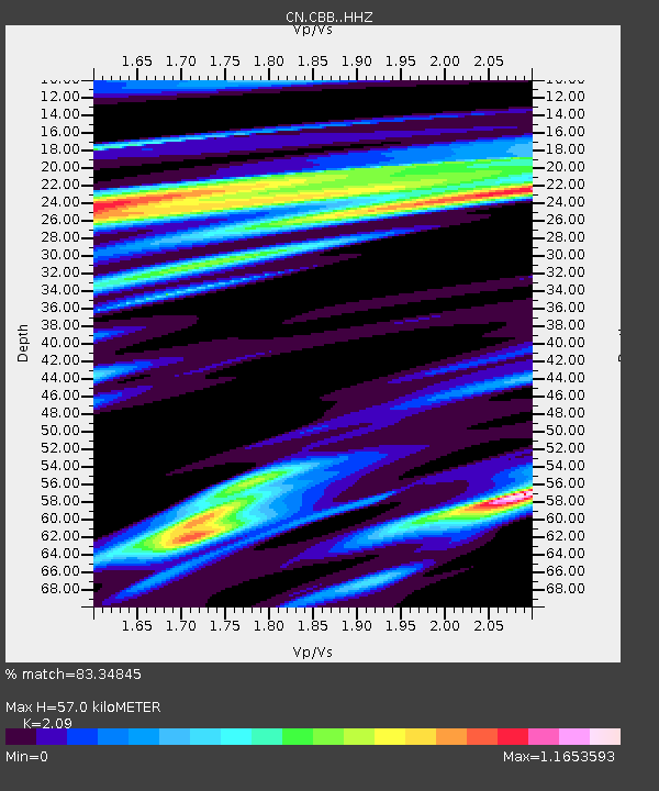
| Estimated Moho Depth: |
57.0 km |
| Estimated Crust Vp/Vs: |
2.09 |
| Assumed Crust Vp: |
6.566 km/s |
| Estimated Crust Vs: |
3.142 km/s |
| Estimated Crust Poisson's Ratio: |
0.35 |
|
| Radial Match: |
83.34845 % |
| Radial Bump: |
400 |
| Transverse Match: |
76.58712 % |
| Transverse Bump: |
400 |
| SOD ConfigId: |
19053131 |
| Insert Time: |
2019-09-16 22:52:20.448 +0000 |
| GWidth: |
2.5 |
| Max Bumps: |
400 |
| Tol: |
0.001 |
|

Signal To Noise
| Channel | StoN | STA | LTA |
| CN:CBB: :HHZ:20190902T22:56:04.020002Z | 4.566627 | 6.780818E-7 | 1.4848636E-7 |
| CN:CBB: :HHN:20190902T22:56:04.020002Z | 1.2256036 | 1.209251E-7 | 9.866576E-8 |
| CN:CBB: :HHE:20190902T22:56:04.020002Z | 2.6012022 | 3.9384156E-7 | 1.514075E-7 |
| Arrivals |
| Ps | 9.8 SECOND |
| PpPs | 26 SECOND |
| PsPs/PpSs | 36 SECOND |


