You are here: Home > Network List > TA - USArray Transportable Network (new EarthScope stations) Stations List
> Station N14A Grayback Hills BLM, Clive, UT, USA > Earthquake Result Viewer
N14A Grayback Hills BLM, Clive, UT, USA - Earthquake Result Viewer
| Earthquake location: |
Andreanof Islands, Aleutian Is. |
| Earthquake latitude/longitude: |
52.2/-178.7 |
| Earthquake time(UTC): |
2008/03/22 (082) 21:24:11 GMT |
| Earthquake Depth: |
132 km |
| Earthquake Magnitude: |
5.8 MB, 6.2 MW, 6.1 MW |
| Earthquake Catalog/Contributor: |
WHDF/NEIC |
|
| Network: |
TA USArray Transportable Network (new EarthScope stations) |
| Station: |
N14A Grayback Hills BLM, Clive, UT, USA |
| Lat/Lon: |
40.85 N/113.19 W |
| Elevation: |
1325 m |
|
| Distance: |
45.0 deg |
| Az: |
77.452 deg |
| Baz: |
307.59 deg |
| Ray Param: |
0.07106639 |
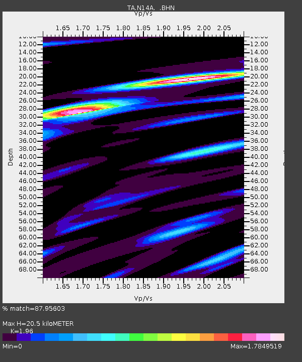
| Estimated Moho Depth: |
20.5 km |
| Estimated Crust Vp/Vs: |
1.96 |
| Assumed Crust Vp: |
6.276 km/s |
| Estimated Crust Vs: |
3.202 km/s |
| Estimated Crust Poisson's Ratio: |
0.32 |
|
| Radial Match: |
87.95603 % |
| Radial Bump: |
340 |
| Transverse Match: |
74.05128 % |
| Transverse Bump: |
375 |
| SOD ConfigId: |
2564 |
| Insert Time: |
2010-03-07 04:02:21.022 +0000 |
| GWidth: |
2.5 |
| Max Bumps: |
400 |
| Tol: |
0.001 |
|
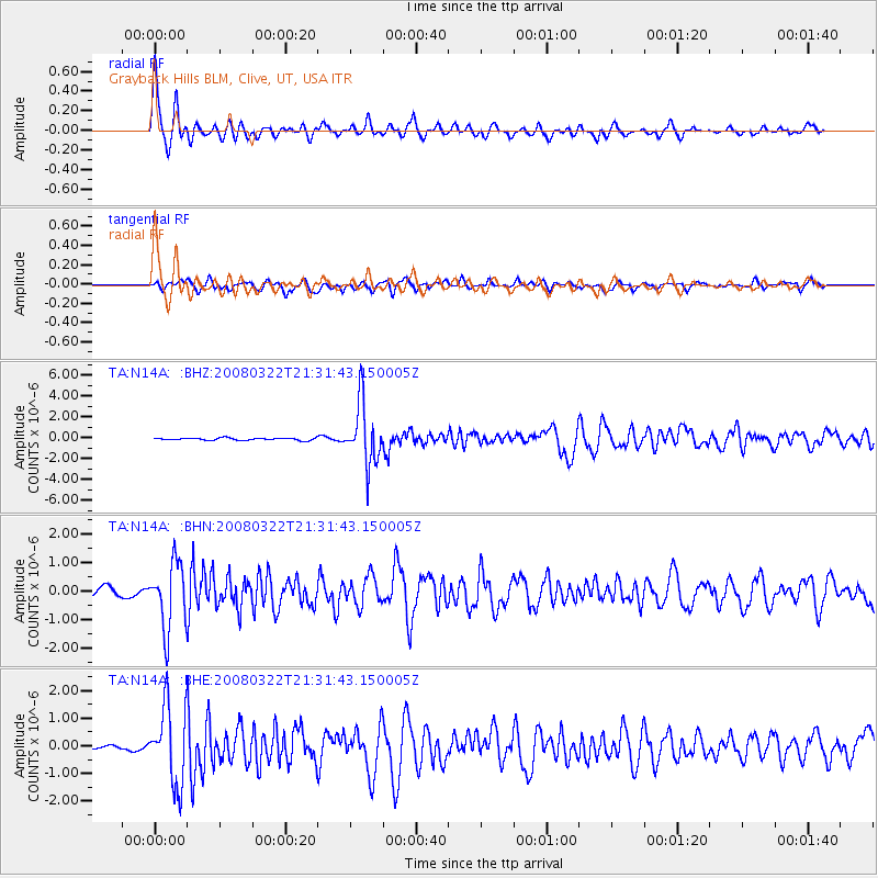
Signal To Noise
| Channel | StoN | STA | LTA |
| TA:N14A: :BHN:20080322T21:31:43.150005Z | 4.3521523 | 1.1348798E-6 | 2.6076287E-7 |
| TA:N14A: :BHE:20080322T21:31:43.150005Z | 11.820455 | 1.4011842E-6 | 1.1853894E-7 |
| TA:N14A: :BHZ:20080322T21:31:43.150005Z | 26.531214 | 2.8732488E-6 | 1.0829692E-7 |
| Arrivals |
| Ps | 3.3 SECOND |
| PpPs | 9.2 SECOND |
| PsPs/PpSs | 12 SECOND |


