You are here: Home > Network List > TA - USArray Transportable Network (new EarthScope stations) Stations List
> Station N14A Grayback Hills BLM, Clive, UT, USA > Earthquake Result Viewer
N14A Grayback Hills BLM, Clive, UT, USA - Earthquake Result Viewer
| Earthquake location: |
Andreanof Islands, Aleutian Is. |
| Earthquake latitude/longitude: |
51.4/-179.0 |
| Earthquake time(UTC): |
2007/12/21 (355) 07:24:34 GMT |
| Earthquake Depth: |
30 km |
| Earthquake Magnitude: |
6.1 MB, 6.2 MW, 6.3 ML |
| Earthquake Catalog/Contributor: |
WHDF/NEIC |
|
| Network: |
TA USArray Transportable Network (new EarthScope stations) |
| Station: |
N14A Grayback Hills BLM, Clive, UT, USA |
| Lat/Lon: |
40.85 N/113.19 W |
| Elevation: |
1325 m |
|
| Distance: |
45.4 deg |
| Az: |
76.493 deg |
| Baz: |
306.517 deg |
| Ray Param: |
0.07127111 |
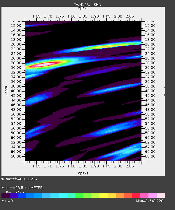
| Estimated Moho Depth: |
28.5 km |
| Estimated Crust Vp/Vs: |
1.68 |
| Assumed Crust Vp: |
6.276 km/s |
| Estimated Crust Vs: |
3.741 km/s |
| Estimated Crust Poisson's Ratio: |
0.22 |
|
| Radial Match: |
83.18234 % |
| Radial Bump: |
400 |
| Transverse Match: |
62.731953 % |
| Transverse Bump: |
400 |
| SOD ConfigId: |
2564 |
| Insert Time: |
2010-03-07 04:02:26.178 +0000 |
| GWidth: |
2.5 |
| Max Bumps: |
400 |
| Tol: |
0.001 |
|
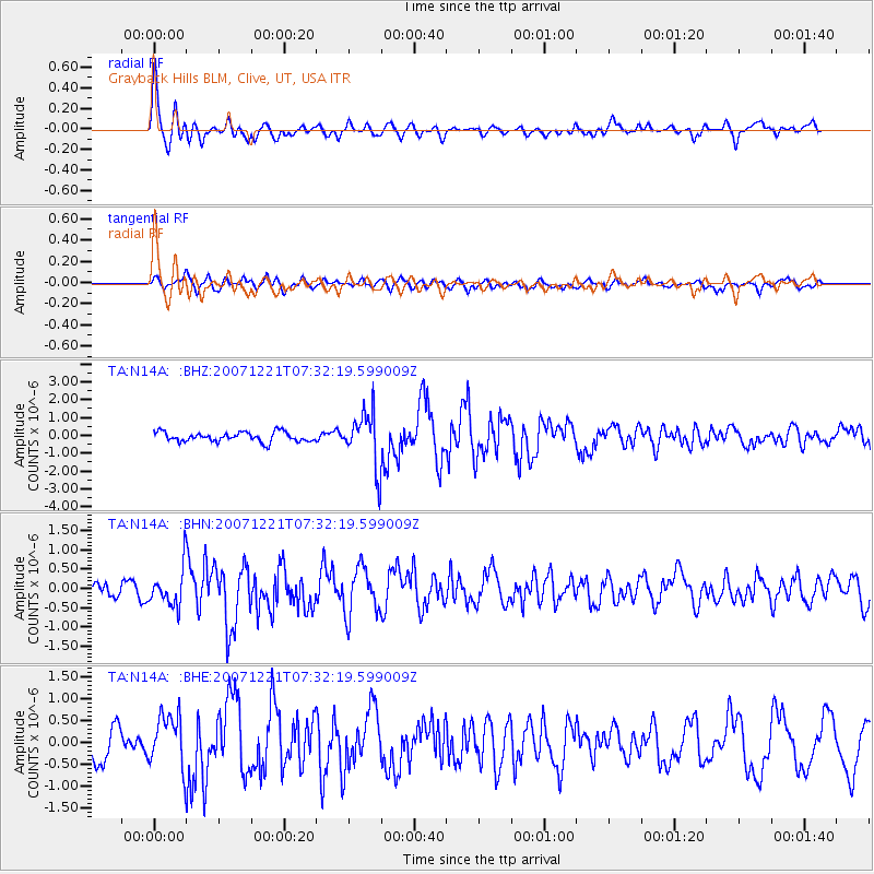
Signal To Noise
| Channel | StoN | STA | LTA |
| TA:N14A: :BHN:20071221T07:32:19.599009Z | 2.367026 | 4.829946E-7 | 2.0405125E-7 |
| TA:N14A: :BHE:20071221T07:32:19.599009Z | 1.6500914 | 5.991144E-7 | 3.630795E-7 |
| TA:N14A: :BHZ:20071221T07:32:19.599009Z | 5.745856 | 1.5357072E-6 | 2.6727213E-7 |
| Arrivals |
| Ps | 3.3 SECOND |
| PpPs | 11 SECOND |
| PsPs/PpSs | 15 SECOND |


