You are here: Home > Network List > TA - USArray Transportable Network (new EarthScope stations) Stations List
> Station N14A Grayback Hills BLM, Clive, UT, USA > Earthquake Result Viewer
N14A Grayback Hills BLM, Clive, UT, USA - Earthquake Result Viewer
| Earthquake location: |
South Of Fiji Islands |
| Earthquake latitude/longitude: |
-26.0/-177.5 |
| Earthquake time(UTC): |
2007/12/09 (343) 07:28:20 GMT |
| Earthquake Depth: |
152 km |
| Earthquake Magnitude: |
7.0 MB, 7.8 MW, 7.7 MW |
| Earthquake Catalog/Contributor: |
WHDF/NEIC |
|
| Network: |
TA USArray Transportable Network (new EarthScope stations) |
| Station: |
N14A Grayback Hills BLM, Clive, UT, USA |
| Lat/Lon: |
40.85 N/113.19 W |
| Elevation: |
1325 m |
|
| Distance: |
89.3 deg |
| Az: |
43.137 deg |
| Baz: |
234.213 deg |
| Ray Param: |
0.041720398 |
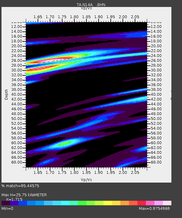
| Estimated Moho Depth: |
25.75 km |
| Estimated Crust Vp/Vs: |
1.72 |
| Assumed Crust Vp: |
6.276 km/s |
| Estimated Crust Vs: |
3.659 km/s |
| Estimated Crust Poisson's Ratio: |
0.24 |
|
| Radial Match: |
95.44575 % |
| Radial Bump: |
328 |
| Transverse Match: |
86.91099 % |
| Transverse Bump: |
400 |
| SOD ConfigId: |
2564 |
| Insert Time: |
2010-03-07 04:02:31.484 +0000 |
| GWidth: |
2.5 |
| Max Bumps: |
400 |
| Tol: |
0.001 |
|
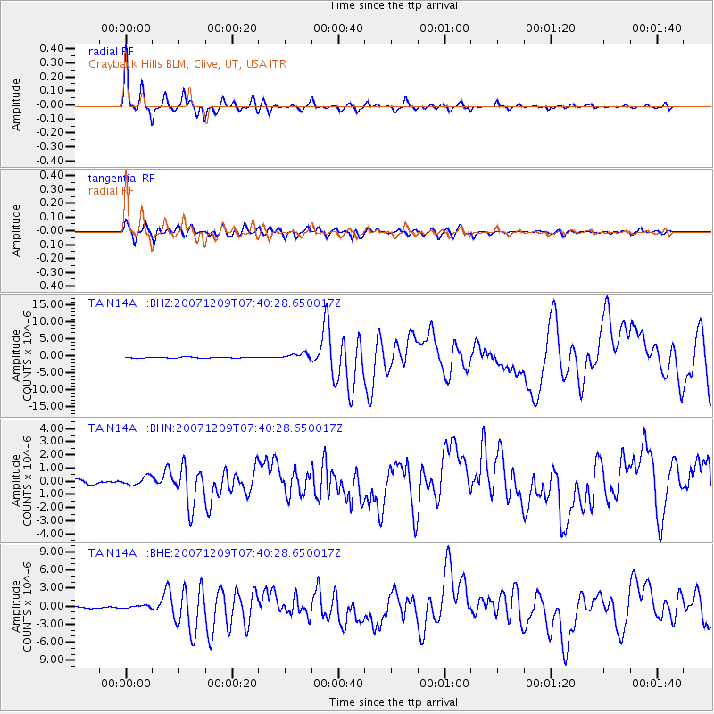
Signal To Noise
| Channel | StoN | STA | LTA |
| TA:N14A: :BHN:20071209T07:40:28.650017Z | 2.4123926 | 3.3227718E-7 | 1.377376E-7 |
| TA:N14A: :BHE:20071209T07:40:28.650017Z | 2.224218 | 2.819562E-7 | 1.2676645E-7 |
| TA:N14A: :BHZ:20071209T07:40:28.650017Z | 6.033008 | 9.288353E-7 | 1.539589E-7 |
| Arrivals |
| Ps | 3.0 SECOND |
| PpPs | 11 SECOND |
| PsPs/PpSs | 14 SECOND |


