You are here: Home > Network List > TA - USArray Transportable Network (new EarthScope stations) Stations List
> Station N14A Grayback Hills BLM, Clive, UT, USA > Earthquake Result Viewer
N14A Grayback Hills BLM, Clive, UT, USA - Earthquake Result Viewer
| Earthquake location: |
Peru-Ecuador Border Region |
| Earthquake latitude/longitude: |
-2.3/-77.8 |
| Earthquake time(UTC): |
2007/11/16 (320) 03:13:00 GMT |
| Earthquake Depth: |
123 km |
| Earthquake Magnitude: |
6.3 MB, 6.8 MW, 6.7 MW |
| Earthquake Catalog/Contributor: |
WHDF/NEIC |
|
| Network: |
TA USArray Transportable Network (new EarthScope stations) |
| Station: |
N14A Grayback Hills BLM, Clive, UT, USA |
| Lat/Lon: |
40.85 N/113.19 W |
| Elevation: |
1325 m |
|
| Distance: |
53.7 deg |
| Az: |
327.002 deg |
| Baz: |
134.163 deg |
| Ray Param: |
0.06553488 |
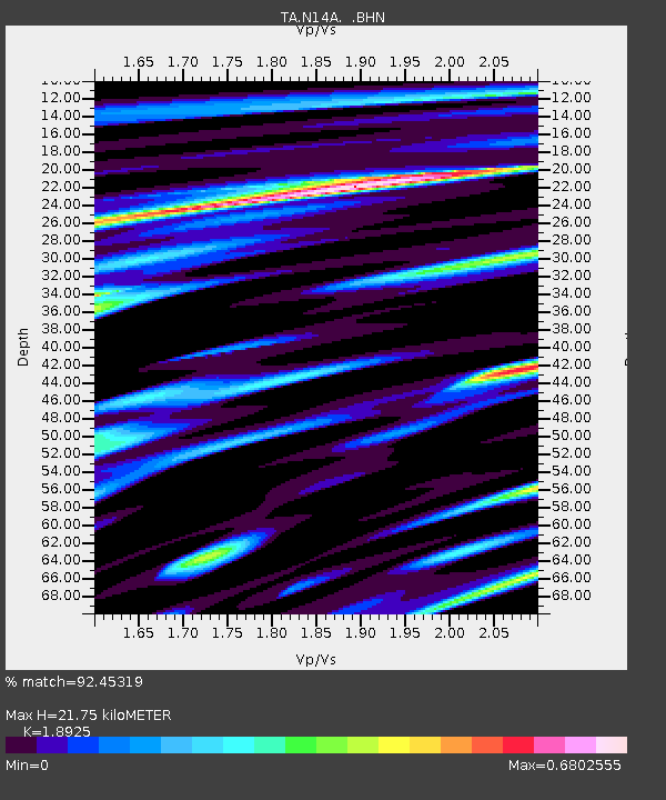
| Estimated Moho Depth: |
21.75 km |
| Estimated Crust Vp/Vs: |
1.89 |
| Assumed Crust Vp: |
6.276 km/s |
| Estimated Crust Vs: |
3.316 km/s |
| Estimated Crust Poisson's Ratio: |
0.31 |
|
| Radial Match: |
92.45319 % |
| Radial Bump: |
400 |
| Transverse Match: |
84.96754 % |
| Transverse Bump: |
400 |
| SOD ConfigId: |
2564 |
| Insert Time: |
2010-03-07 04:02:36.192 +0000 |
| GWidth: |
2.5 |
| Max Bumps: |
400 |
| Tol: |
0.001 |
|

Signal To Noise
| Channel | StoN | STA | LTA |
| TA:N14A: :BHN:20071116T03:21:38.674016Z | 2.6578994 | 3.8620865E-7 | 1.4530598E-7 |
| TA:N14A: :BHE:20071116T03:21:38.674016Z | 2.0695224 | 5.016153E-7 | 2.4238216E-7 |
| TA:N14A: :BHZ:20071116T03:21:38.674016Z | 6.9688044 | 1.1677317E-6 | 1.6756557E-7 |
| Arrivals |
| Ps | 3.2 SECOND |
| PpPs | 9.6 SECOND |
| PsPs/PpSs | 13 SECOND |


