You are here: Home > Network List > TA - USArray Transportable Network (new EarthScope stations) Stations List
> Station N14A Grayback Hills BLM, Clive, UT, USA > Earthquake Result Viewer
N14A Grayback Hills BLM, Clive, UT, USA - Earthquake Result Viewer
| Earthquake location: |
Northwest Of Ryukyu Islands |
| Earthquake latitude/longitude: |
27.3/126.8 |
| Earthquake time(UTC): |
2007/08/07 (219) 00:02:24 GMT |
| Earthquake Depth: |
18 km |
| Earthquake Magnitude: |
5.5 MB, 5.8 MS, 5.9 MW, 5.9 MW |
| Earthquake Catalog/Contributor: |
WHDF/NEIC |
|
| Network: |
TA USArray Transportable Network (new EarthScope stations) |
| Station: |
N14A Grayback Hills BLM, Clive, UT, USA |
| Lat/Lon: |
40.85 N/113.19 W |
| Elevation: |
1325 m |
|
| Distance: |
92.3 deg |
| Az: |
41.119 deg |
| Baz: |
309.511 deg |
| Ray Param: |
0.04147639 |
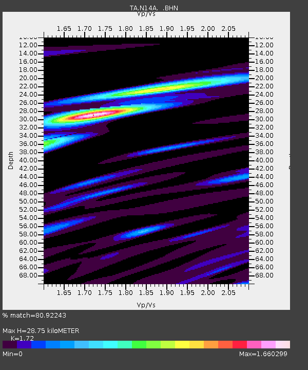
| Estimated Moho Depth: |
28.75 km |
| Estimated Crust Vp/Vs: |
1.72 |
| Assumed Crust Vp: |
6.276 km/s |
| Estimated Crust Vs: |
3.649 km/s |
| Estimated Crust Poisson's Ratio: |
0.24 |
|
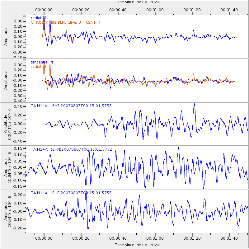
| Radial Match: |
80.92243 % |
| Radial Bump: |
400 |
| Transverse Match: |
63.710014 % |
| Transverse Bump: |
400 |
| SOD ConfigId: |
2564 |
| Insert Time: |
2010-03-07 04:03:07.729 +0000 |
| GWidth: |
2.5 |
| Max Bumps: |
400 |
| Tol: |
0.001 |
|
Signal To Noise
| Channel | StoN | STA | LTA |
| TA:N14A: :BHN:20070807T00:15:01.575Z | 1.5934695 | 5.639632E-8 | 3.5392155E-8 |
| TA:N14A: :BHE:20070807T00:15:01.575Z | 1.163564 | 3.4137763E-8 | 2.9338965E-8 |
| TA:N14A: :BHZ:20070807T00:15:01.575Z | 2.3634715 | 1.0654779E-7 | 4.5081055E-8 |
| Arrivals |
| Ps | 3.4 SECOND |
| PpPs | 12 SECOND |
| PsPs/PpSs | 16 SECOND |


