You are here: Home > Network List > TA - USArray Transportable Network (new EarthScope stations) Stations List
> Station N14A Grayback Hills BLM, Clive, UT, USA > Earthquake Result Viewer
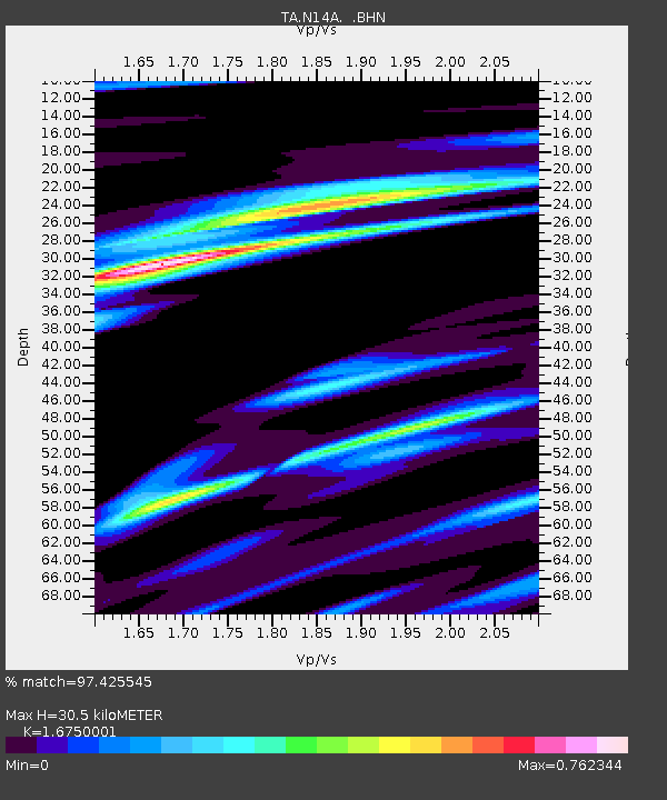
N14A Grayback Hills BLM, Clive, UT, USA - Earthquake Result Viewer
| Earthquake location: |
Vanuatu Islands |
| Earthquake latitude/longitude: |
-15.6/167.7 |
| Earthquake time(UTC): |
2007/08/01 (213) 17:08:51 GMT |
| Earthquake Depth: |
120 km |
| Earthquake Magnitude: |
6.2 MB, 7.2 MW, 7.2 MW |
| Earthquake Catalog/Contributor: |
WHDF/NEIC |
|
| Network: |
TA USArray Transportable Network (new EarthScope stations) |
| Station: |
N14A Grayback Hills BLM, Clive, UT, USA |
| Lat/Lon: |
40.85 N/113.19 W |
| Elevation: |
1325 m |
|
| Distance: |
92.1 deg |
| Az: |
48.199 deg |
| Baz: |
251.261 deg |
| Ray Param: |
0.04146142 |
| Estimated Moho Depth: |
30.5 km |
| Estimated Crust Vp/Vs: |
1.68 |
| Assumed Crust Vp: |
6.276 km/s |
| Estimated Crust Vs: |
3.747 km/s |
| Estimated Crust Poisson's Ratio: |
0.22 |
|
| Radial Match: |
97.425545 % |
| Radial Bump: |
263 |
| Transverse Match: |
90.379395 % |
| Transverse Bump: |
400 |
| SOD ConfigId: |
2564 |
| Insert Time: |
2010-03-07 04:03:13.229 +0000 |
| GWidth: |
2.5 |
| Max Bumps: |
400 |
| Tol: |
0.001 |
|

Signal To Noise
| Channel | StoN | STA | LTA |
| TA:N14A: :BHN:20070801T17:21:15.725012Z | 2.0737114 | 7.419151E-8 | 3.5777163E-8 |
| TA:N14A: :BHE:20070801T17:21:15.725012Z | 1.541448 | 1.1121658E-7 | 7.215071E-8 |
| TA:N14A: :BHZ:20070801T17:21:15.725012Z | 4.173746 | 4.911895E-7 | 1.17685516E-7 |
| Arrivals |
| Ps | 3.3 SECOND |
| PpPs | 13 SECOND |
| PsPs/PpSs | 16 SECOND |


