You are here: Home > Network List > TA - USArray Transportable Network (new EarthScope stations) Stations List
> Station N14A Grayback Hills BLM, Clive, UT, USA > Earthquake Result Viewer
N14A Grayback Hills BLM, Clive, UT, USA - Earthquake Result Viewer
| Earthquake location: |
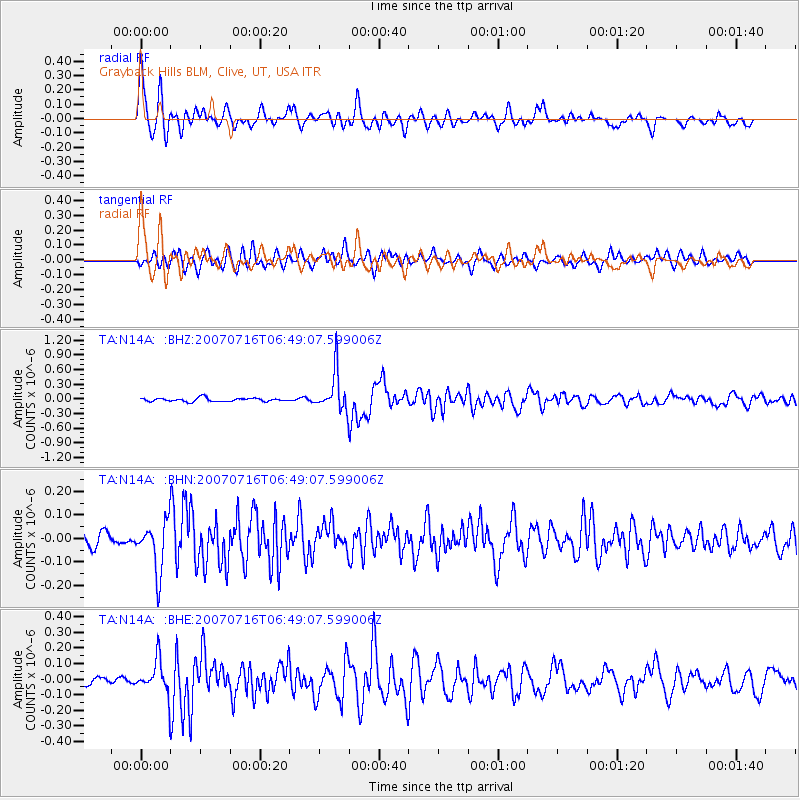
Near West Coast Of Honshu, Japan |
| Earthquake latitude/longitude: |
37.5/138.5 |
| Earthquake time(UTC): |
2007/07/16 (197) 06:37:40 GMT |
| Earthquake Depth: |
15 km |
| Earthquake Magnitude: |
5.7 MB, 5.1 MS, 5.7 MW, 5.6 MW |
| Earthquake Catalog/Contributor: |
WHDF/NEIC |
|
| Network: |
TA USArray Transportable Network (new EarthScope stations) |
| Station: |
N14A Grayback Hills BLM, Clive, UT, USA |
| Lat/Lon: |
40.85 N/113.19 W |
| Elevation: |
1325 m |
|
| Distance: |
78.2 deg |
| Az: |
47.363 deg |
| Baz: |
309.532 deg |
| Ray Param: |
0.049818423 |
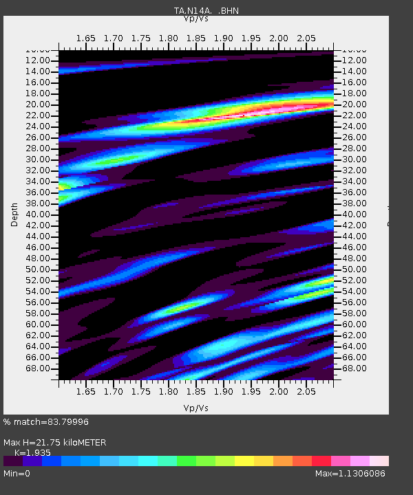
| Estimated Moho Depth: |
21.75 km |
| Estimated Crust Vp/Vs: |
1.93 |
| Assumed Crust Vp: |
6.276 km/s |
| Estimated Crust Vs: |
3.243 km/s |
| Estimated Crust Poisson's Ratio: |
0.32 |
|
| Radial Match: |
83.79996 % |
| Radial Bump: |
400 |
| Transverse Match: |
73.54609 % |
| Transverse Bump: |
400 |
| SOD ConfigId: |
2564 |
| Insert Time: |
2010-03-07 04:03:19.445 +0000 |
| GWidth: |
2.5 |
| Max Bumps: |
400 |
| Tol: |
0.001 |
|
Signal To Noise
| Channel | StoN | STA | LTA |
| TA:N14A: :BHN:20070716T06:49:07.599006Z | 3.7461553 | 1.06225585E-7 | 2.8355895E-8 |
| TA:N14A: :BHE:20070716T06:49:07.599006Z | 2.8459246 | 1.08241665E-7 | 3.8033917E-8 |
| TA:N14A: :BHZ:20070716T06:49:07.599006Z | 11.06315 | 3.9372358E-7 | 3.558874E-8 |
| Arrivals |
| Ps | 3.3 SECOND |
| PpPs | 9.9 SECOND |
| PsPs/PpSs | 13 SECOND |


