You are here: Home > Network List > IW - Intermountain West Stations List
> Station PLID Pearl Lake, Idaho, USA > Earthquake Result Viewer
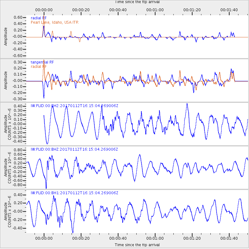
PLID Pearl Lake, Idaho, USA - Earthquake Result Viewer
*The percent match for this event was below the threshold and hence no stack was calculated.
| Earthquake location: |
Near West Coast Of Colombia |
| Earthquake latitude/longitude: |
6.1/-77.9 |
| Earthquake time(UTC): |
2017/01/12 (012) 16:06:31 GMT |
| Earthquake Depth: |
3.3 km |
| Earthquake Magnitude: |
5.5 mb |
| Earthquake Catalog/Contributor: |
NEIC PDE/us |
|
| Network: |
IW Intermountain West |
| Station: |
PLID Pearl Lake, Idaho, USA |
| Lat/Lon: |
45.09 N/116.00 W |
| Elevation: |
2164 m |
|
| Distance: |
51.1 deg |
| Az: |
325.832 deg |
| Baz: |
127.961 deg |
| Ray Param: |
$rayparam |
*The percent match for this event was below the threshold and hence was not used in the summary stack. |
|
| Radial Match: |
66.29409 % |
| Radial Bump: |
390 |
| Transverse Match: |
53.173733 % |
| Transverse Bump: |
400 |
| SOD ConfigId: |
1943534 |
| Insert Time: |
2017-01-26 16:08:43.355 +0000 |
| GWidth: |
2.5 |
| Max Bumps: |
400 |
| Tol: |
0.001 |
|
Signal To Noise
| Channel | StoN | STA | LTA |
| IW:PLID:00:BHZ:20170112T16:15:04.269006Z | 1.8724904 | 4.321283E-7 | 2.307773E-7 |
| IW:PLID:00:BH1:20170112T16:15:04.269006Z | 0.8417561 | 1.2512021E-7 | 1.4864187E-7 |
| IW:PLID:00:BH2:20170112T16:15:04.269006Z | 0.88256544 | 1.9907192E-7 | 2.2556051E-7 |
| Arrivals |
| Ps | |
| PpPs | |
| PsPs/PpSs | |


