You are here: Home > Network List > TS - TERRAscope (Southern California Seismic Network) Stations List
> Station MLAC Mammoth Lakes, California, USA > Earthquake Result Viewer
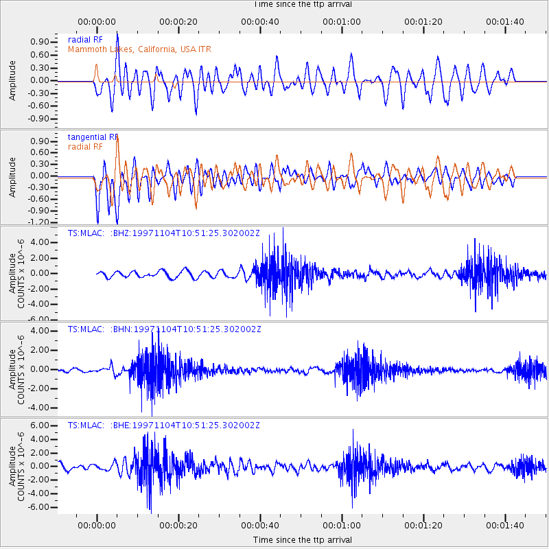
MLAC Mammoth Lakes, California, USA - Earthquake Result Viewer
*The percent match for this event was below the threshold and hence no stack was calculated.
| Earthquake location: |
Fiji Islands Region |
| Earthquake latitude/longitude: |
-21.0/-179.2 |
| Earthquake time(UTC): |
1997/11/04 (308) 10:40:43 GMT |
| Earthquake Depth: |
621 km |
| Earthquake Magnitude: |
5.7 UNKNOWN, 5.1 MB |
| Earthquake Catalog/Contributor: |
WHDF/NEIC |
|
| Network: |
TS TERRAscope (Southern California Seismic Network) |
| Station: |
MLAC Mammoth Lakes, California, USA |
| Lat/Lon: |
37.63 N/118.83 W |
| Elevation: |
2170 m |
|
| Distance: |
81.4 deg |
| Az: |
44.266 deg |
| Baz: |
235.216 deg |
| Ray Param: |
$rayparam |
*The percent match for this event was below the threshold and hence was not used in the summary stack. |
|
| Radial Match: |
58.588688 % |
| Radial Bump: |
400 |
| Transverse Match: |
54.768703 % |
| Transverse Bump: |
400 |
| SOD ConfigId: |
4480 |
| Insert Time: |
2010-02-26 14:28:09.411 +0000 |
| GWidth: |
2.5 |
| Max Bumps: |
400 |
| Tol: |
0.001 |
|
Signal To Noise
| Channel | StoN | STA | LTA |
| TS:MLAC: :BHN:19971104T10:51:25.302002Z | 3.0593395 | 3.8083482E-7 | 1.2448268E-7 |
| TS:MLAC: :BHE:19971104T10:51:25.302002Z | 1.0232799 | 5.1304164E-7 | 5.013698E-7 |
| TS:MLAC: :BHZ:19971104T10:51:25.302002Z | 0.9333377 | 3.905764E-7 | 4.1847272E-7 |
| Arrivals |
| Ps | |
| PpPs | |
| PsPs/PpSs | |


