You are here: Home > Network List > TA - USArray Transportable Network (new EarthScope stations) Stations List
> Station E20K Nigu River, AK, USA > Earthquake Result Viewer
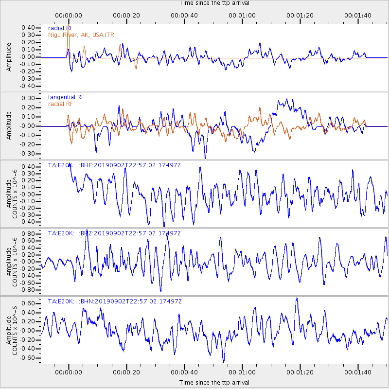
E20K Nigu River, AK, USA - Earthquake Result Viewer
*The percent match for this event was below the threshold and hence no stack was calculated.
| Earthquake location: |
Northern Mid-Atlantic Ridge |
| Earthquake latitude/longitude: |
23.8/-45.2 |
| Earthquake time(UTC): |
2019/09/02 (245) 22:45:48 GMT |
| Earthquake Depth: |
10 km |
| Earthquake Magnitude: |
5.9 Mww |
| Earthquake Catalog/Contributor: |
NEIC PDE/us |
|
| Network: |
TA USArray Transportable Network (new EarthScope stations) |
| Station: |
E20K Nigu River, AK, USA |
| Lat/Lon: |
68.26 N/156.19 W |
| Elevation: |
866 m |
|
| Distance: |
75.6 deg |
| Az: |
338.945 deg |
| Baz: |
62.069 deg |
| Ray Param: |
$rayparam |
*The percent match for this event was below the threshold and hence was not used in the summary stack. |
|
| Radial Match: |
44.221733 % |
| Radial Bump: |
400 |
| Transverse Match: |
34.472446 % |
| Transverse Bump: |
400 |
| SOD ConfigId: |
19053131 |
| Insert Time: |
2019-09-16 22:58:37.926 +0000 |
| GWidth: |
2.5 |
| Max Bumps: |
400 |
| Tol: |
0.001 |
|
Signal To Noise
| Channel | StoN | STA | LTA |
| TA:E20K: :BHZ:20190902T22:57:02.17497Z | 1.2840463 | 2.1003392E-7 | 1.6357193E-7 |
| TA:E20K: :BHN:20190902T22:57:02.17497Z | 0.8526955 | 2.1666344E-7 | 2.5409238E-7 |
| TA:E20K: :BHE:20190902T22:57:02.17497Z | 1.3396044 | 2.3183634E-7 | 1.7306328E-7 |
| Arrivals |
| Ps | |
| PpPs | |
| PsPs/PpSs | |


