You are here: Home > Network List > US - United States National Seismic Network Stations List
> Station OGNE Ogallala, Nebraska, USA > Earthquake Result Viewer
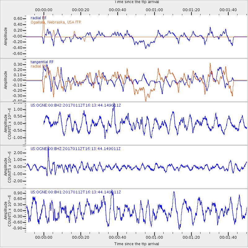
OGNE Ogallala, Nebraska, USA - Earthquake Result Viewer
*The percent match for this event was below the threshold and hence no stack was calculated.
| Earthquake location: |
Near West Coast Of Colombia |
| Earthquake latitude/longitude: |
6.1/-77.9 |
| Earthquake time(UTC): |
2017/01/12 (012) 16:06:31 GMT |
| Earthquake Depth: |
3.3 km |
| Earthquake Magnitude: |
5.5 mb |
| Earthquake Catalog/Contributor: |
NEIC PDE/us |
|
| Network: |
US United States National Seismic Network |
| Station: |
OGNE Ogallala, Nebraska, USA |
| Lat/Lon: |
40.95 N/102.03 W |
| Elevation: |
1054 m |
|
| Distance: |
40.9 deg |
| Az: |
331.796 deg |
| Baz: |
141.65 deg |
| Ray Param: |
$rayparam |
*The percent match for this event was below the threshold and hence was not used in the summary stack. |
|
| Radial Match: |
54.751015 % |
| Radial Bump: |
400 |
| Transverse Match: |
52.104847 % |
| Transverse Bump: |
400 |
| SOD ConfigId: |
1943534 |
| Insert Time: |
2017-01-26 16:10:27.660 +0000 |
| GWidth: |
2.5 |
| Max Bumps: |
400 |
| Tol: |
0.001 |
|
Signal To Noise
| Channel | StoN | STA | LTA |
| US:OGNE:00:BHZ:20170112T16:13:44.149011Z | 4.265464 | 8.605254E-7 | 2.0174251E-7 |
| US:OGNE:00:BH1:20170112T16:13:44.149011Z | 0.86401796 | 3.7455715E-7 | 4.3350622E-7 |
| US:OGNE:00:BH2:20170112T16:13:44.149011Z | 1.0459638 | 4.443886E-7 | 4.248604E-7 |
| Arrivals |
| Ps | |
| PpPs | |
| PsPs/PpSs | |


