You are here: Home > Network List > TX - Texas Seismological Network Stations List
> Station WTFS Witchita Falls > Earthquake Result Viewer
WTFS Witchita Falls - Earthquake Result Viewer
*The percent match for this event was below the threshold and hence no stack was calculated.
| Earthquake location: |
Northern Mid-Atlantic Ridge |
| Earthquake latitude/longitude: |
23.8/-45.2 |
| Earthquake time(UTC): |
2019/09/02 (245) 22:45:48 GMT |
| Earthquake Depth: |
10 km |
| Earthquake Magnitude: |
5.9 Mww |
| Earthquake Catalog/Contributor: |
NEIC PDE/us |
|
| Network: |
TX Texas Seismological Network |
| Station: |
WTFS Witchita Falls |
| Lat/Lon: |
33.77 N/98.46 W |
| Elevation: |
277 m |
|
| Distance: |
47.3 deg |
| Az: |
294.72 deg |
| Baz: |
87.633 deg |
| Ray Param: |
$rayparam |
*The percent match for this event was below the threshold and hence was not used in the summary stack. |
|
| Radial Match: |
78.94446 % |
| Radial Bump: |
400 |
| Transverse Match: |
70.71937 % |
| Transverse Bump: |
400 |
| SOD ConfigId: |
19053131 |
| Insert Time: |
2019-09-16 23:00:20.199 +0000 |
| GWidth: |
2.5 |
| Max Bumps: |
400 |
| Tol: |
0.001 |
|
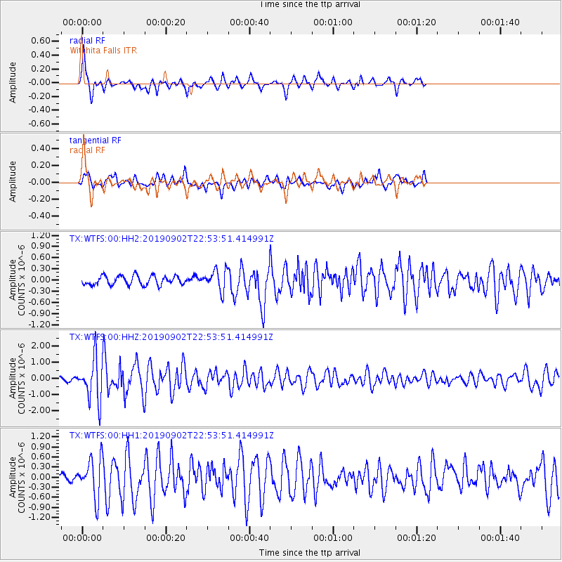
Signal To Noise
| Channel | StoN | STA | LTA |
| TX:WTFS:00:HHZ:20190902T22:53:51.414991Z | 12.815171 | 1.3192741E-6 | 1.0294627E-7 |
| TX:WTFS:00:HH1:20190902T22:53:51.414991Z | 5.570658 | 5.982687E-7 | 1.0739641E-7 |
| TX:WTFS:00:HH2:20190902T22:53:51.414991Z | 2.3528073 | 2.8379404E-7 | 1.2061932E-7 |
| Arrivals |
| Ps | |
| PpPs | |
| PsPs/PpSs | |


