You are here: Home > Network List > TA - USArray Transportable Network (new EarthScope stations) Stations List
> Station V03C Hunter Liggett MR Jolon, CA, USA > Earthquake Result Viewer
V03C Hunter Liggett MR Jolon, CA, USA - Earthquake Result Viewer
| Earthquake location: |
Peru-Ecuador Border Region |
| Earthquake latitude/longitude: |
-2.3/-77.8 |
| Earthquake time(UTC): |
2007/11/16 (320) 03:13:00 GMT |
| Earthquake Depth: |
123 km |
| Earthquake Magnitude: |
6.3 MB, 6.8 MW, 6.7 MW |
| Earthquake Catalog/Contributor: |
WHDF/NEIC |
|
| Network: |
TA USArray Transportable Network (new EarthScope stations) |
| Station: |
V03C Hunter Liggett MR Jolon, CA, USA |
| Lat/Lon: |
36.02 N/121.24 W |
| Elevation: |
336 m |
|
| Distance: |
55.6 deg |
| Az: |
317.538 deg |
| Baz: |
123.684 deg |
| Ray Param: |
0.06430866 |
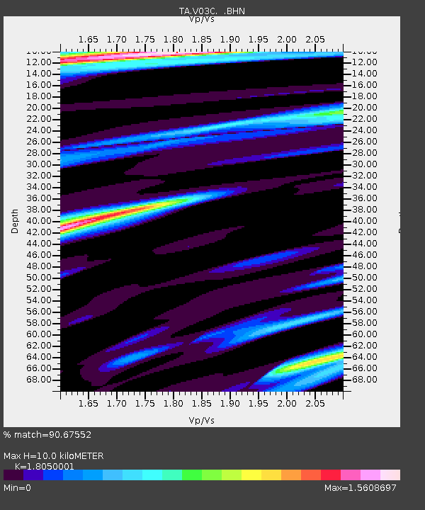
| Estimated Moho Depth: |
10.0 km |
| Estimated Crust Vp/Vs: |
1.81 |
| Assumed Crust Vp: |
6.391 km/s |
| Estimated Crust Vs: |
3.541 km/s |
| Estimated Crust Poisson's Ratio: |
0.28 |
|
| Radial Match: |
90.67552 % |
| Radial Bump: |
400 |
| Transverse Match: |
72.149765 % |
| Transverse Bump: |
400 |
| SOD ConfigId: |
2564 |
| Insert Time: |
2010-03-07 04:05:21.532 +0000 |
| GWidth: |
2.5 |
| Max Bumps: |
400 |
| Tol: |
0.001 |
|

Signal To Noise
| Channel | StoN | STA | LTA |
| TA:V03C: :BHN:20071116T03:21:52.325017Z | 1.2276881 | 7.8806335E-7 | 6.4190846E-7 |
| TA:V03C: :BHE:20071116T03:21:52.325017Z | 1.7894833 | 1.1119758E-6 | 6.213949E-7 |
| TA:V03C: :BHZ:20071116T03:21:52.325017Z | 3.5227797 | 2.6073735E-6 | 7.401466E-7 |
| Arrivals |
| Ps | 1.3 SECOND |
| PpPs | 4.2 SECOND |
| PsPs/PpSs | 5.5 SECOND |


