You are here: Home > Network List > TA - USArray Transportable Network (new EarthScope stations) Stations List
> Station V03C Hunter Liggett MR Jolon, CA, USA > Earthquake Result Viewer
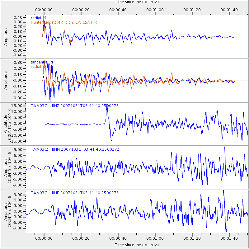
V03C Hunter Liggett MR Jolon, CA, USA - Earthquake Result Viewer

| Earthquake location: |
Mariana Islands |
| Earthquake latitude/longitude: |
18.9/145.4 |
| Earthquake time(UTC): |
2007/10/31 (304) 03:30:17 GMT |
| Earthquake Depth: |
223 km |
| Earthquake Magnitude: |
6.2 MB, 7.2 MW, 7.2 MW |
| Earthquake Catalog/Contributor: |
WHDF/NEIC |
|
| Network: |
TA USArray Transportable Network (new EarthScope stations) |
| Station: |
V03C Hunter Liggett MR Jolon, CA, USA |
| Lat/Lon: |
36.02 N/121.24 W |
| Elevation: |
336 m |
|
| Distance: |
81.8 deg |
| Az: |
54.849 deg |
| Baz: |
287.271 deg |
| Ray Param: |
0.04678958 |
| Estimated Moho Depth: |
26.25 km |
| Estimated Crust Vp/Vs: |
1.77 |
| Assumed Crust Vp: |
6.391 km/s |
| Estimated Crust Vs: |
3.611 km/s |
| Estimated Crust Poisson's Ratio: |
0.27 |
|
| Radial Match: |
84.327065 % |
| Radial Bump: |
400 |
| Transverse Match: |
81.01357 % |
| Transverse Bump: |
400 |
| SOD ConfigId: |
2564 |
| Insert Time: |
2010-03-07 04:05:24.443 +0000 |
| GWidth: |
2.5 |
| Max Bumps: |
400 |
| Tol: |
0.001 |
|
Signal To Noise
| Channel | StoN | STA | LTA |
| TA:V03C: :BHN:20071031T03:41:40.250027Z | 2.488725 | 1.4272902E-6 | 5.735025E-7 |
| TA:V03C: :BHE:20071031T03:41:40.250027Z | 2.2966535 | 1.5488663E-6 | 6.7440135E-7 |
| TA:V03C: :BHZ:20071031T03:41:40.250027Z | 15.974735 | 5.818513E-6 | 3.6423216E-7 |
| Arrivals |
| Ps | 3.2 SECOND |
| PpPs | 11 SECOND |
| PsPs/PpSs | 14 SECOND |


