You are here: Home > Network List > TA - USArray Transportable Network (new EarthScope stations) Stations List
> Station V03C Hunter Liggett MR Jolon, CA, USA > Earthquake Result Viewer
V03C Hunter Liggett MR Jolon, CA, USA - Earthquake Result Viewer
| Earthquake location: |
South Of Fiji Islands |
| Earthquake latitude/longitude: |
-25.8/179.5 |
| Earthquake time(UTC): |
2007/10/16 (289) 21:05:43 GMT |
| Earthquake Depth: |
509 km |
| Earthquake Magnitude: |
6.2 MB, 6.6 MW, 6.5 MW |
| Earthquake Catalog/Contributor: |
WHDF/NEIC |
|
| Network: |
TA USArray Transportable Network (new EarthScope stations) |
| Station: |
V03C Hunter Liggett MR Jolon, CA, USA |
| Lat/Lon: |
36.02 N/121.24 W |
| Elevation: |
336 m |
|
| Distance: |
83.1 deg |
| Az: |
44.564 deg |
| Baz: |
231.303 deg |
| Ray Param: |
0.044985674 |
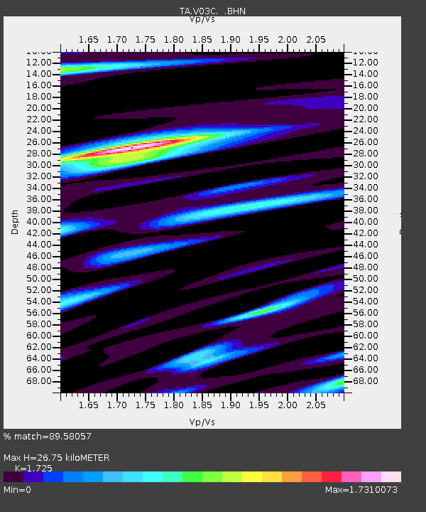
| Estimated Moho Depth: |
26.75 km |
| Estimated Crust Vp/Vs: |
1.73 |
| Assumed Crust Vp: |
6.391 km/s |
| Estimated Crust Vs: |
3.705 km/s |
| Estimated Crust Poisson's Ratio: |
0.25 |
|
| Radial Match: |
89.58057 % |
| Radial Bump: |
400 |
| Transverse Match: |
81.61166 % |
| Transverse Bump: |
400 |
| SOD ConfigId: |
2564 |
| Insert Time: |
2010-03-07 04:05:25.840 +0000 |
| GWidth: |
2.5 |
| Max Bumps: |
400 |
| Tol: |
0.001 |
|
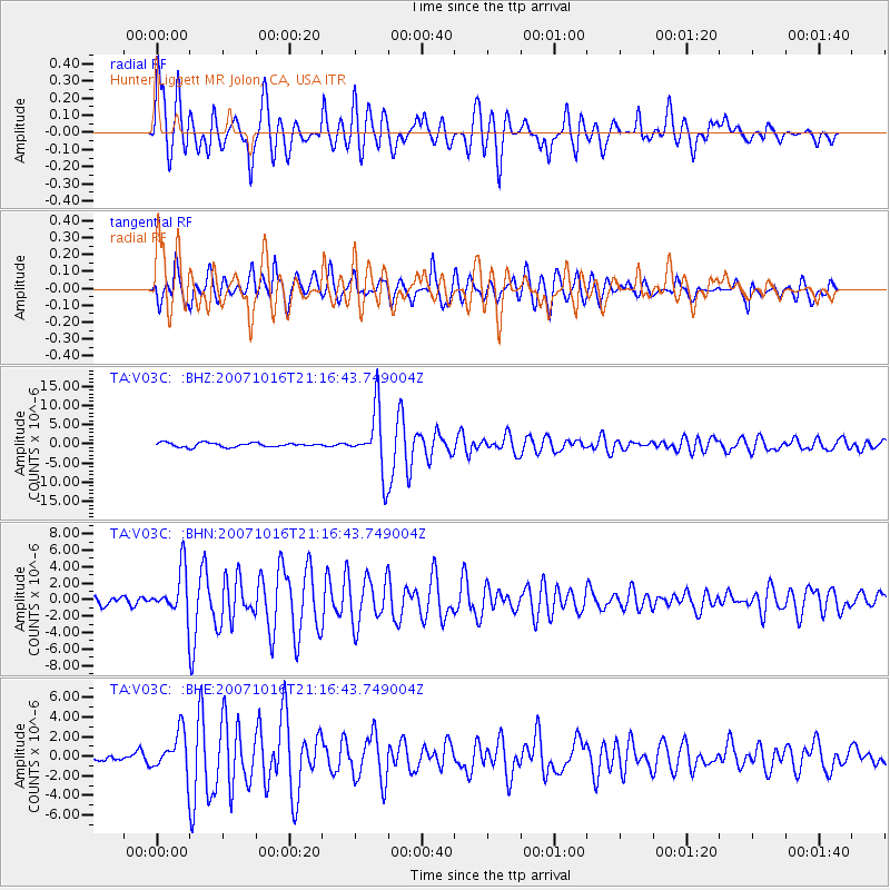
Signal To Noise
| Channel | StoN | STA | LTA |
| TA:V03C: :BHN:20071016T21:16:43.749004Z | 6.644614 | 2.7748247E-6 | 4.176051E-7 |
| TA:V03C: :BHE:20071016T21:16:43.749004Z | 5.531635 | 2.096215E-6 | 3.7895035E-7 |
| TA:V03C: :BHZ:20071016T21:16:43.749004Z | 15.089369 | 8.081955E-6 | 5.3560586E-7 |
| Arrivals |
| Ps | 3.1 SECOND |
| PpPs | 11 SECOND |
| PsPs/PpSs | 14 SECOND |


