You are here: Home > Network List > TA - USArray Transportable Network (new EarthScope stations) Stations List
> Station V03C Hunter Liggett MR Jolon, CA, USA > Earthquake Result Viewer
V03C Hunter Liggett MR Jolon, CA, USA - Earthquake Result Viewer
| Earthquake location: |
Vanuatu Islands |
| Earthquake latitude/longitude: |
-15.4/168.6 |
| Earthquake time(UTC): |
2007/07/15 (196) 09:27:34 GMT |
| Earthquake Depth: |
8.0 km |
| Earthquake Magnitude: |
6.0 MB, 5.8 MS, 6.1 MW, 6.0 MW |
| Earthquake Catalog/Contributor: |
WHDF/NEIC |
|
| Network: |
TA USArray Transportable Network (new EarthScope stations) |
| Station: |
V03C Hunter Liggett MR Jolon, CA, USA |
| Lat/Lon: |
36.02 N/121.24 W |
| Elevation: |
336 m |
|
| Distance: |
83.6 deg |
| Az: |
50.114 deg |
| Baz: |
245.93 deg |
| Ray Param: |
0.046055578 |
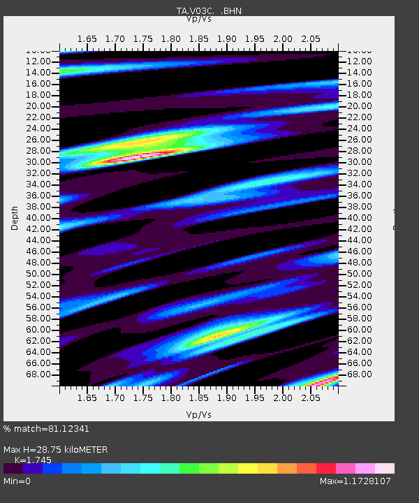
| Estimated Moho Depth: |
28.75 km |
| Estimated Crust Vp/Vs: |
1.75 |
| Assumed Crust Vp: |
6.391 km/s |
| Estimated Crust Vs: |
3.662 km/s |
| Estimated Crust Poisson's Ratio: |
0.26 |
|
| Radial Match: |
81.12341 % |
| Radial Bump: |
400 |
| Transverse Match: |
71.90834 % |
| Transverse Bump: |
400 |
| SOD ConfigId: |
2564 |
| Insert Time: |
2010-03-07 04:05:47.742 +0000 |
| GWidth: |
2.5 |
| Max Bumps: |
400 |
| Tol: |
0.001 |
|

Signal To Noise
| Channel | StoN | STA | LTA |
| TA:V03C: :BHN:20070715T09:39:31.87502Z | 1.5615847 | 1.0760591E-6 | 6.890815E-7 |
| TA:V03C: :BHE:20070715T09:39:31.87502Z | 2.822562 | 1.1135941E-6 | 3.945331E-7 |
| TA:V03C: :BHZ:20070715T09:39:31.87502Z | 10.094673 | 2.430366E-6 | 2.4075726E-7 |
| Arrivals |
| Ps | 3.4 SECOND |
| PpPs | 12 SECOND |
| PsPs/PpSs | 15 SECOND |


