You are here: Home > Network List > G - GEOSCOPE Stations List
> Station NOUC Port Laguerre, New Caledonia > Earthquake Result Viewer
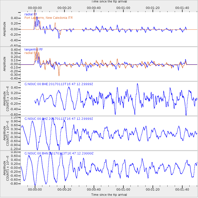
NOUC Port Laguerre, New Caledonia - Earthquake Result Viewer
*The percent match for this event was below the threshold and hence no stack was calculated.
| Earthquake location: |
Northern Molucca Sea |
| Earthquake latitude/longitude: |
0.0/125.1 |
| Earthquake time(UTC): |
2017/01/13 (013) 16:39:25 GMT |
| Earthquake Depth: |
46 km |
| Earthquake Magnitude: |
5.7 mb |
| Earthquake Catalog/Contributor: |
NEIC PDE/us |
|
| Network: |
G GEOSCOPE |
| Station: |
NOUC Port Laguerre, New Caledonia |
| Lat/Lon: |
22.10 S/166.30 E |
| Elevation: |
112 m |
|
| Distance: |
45.8 deg |
| Az: |
121.489 deg |
| Baz: |
293.147 deg |
| Ray Param: |
$rayparam |
*The percent match for this event was below the threshold and hence was not used in the summary stack. |
|
| Radial Match: |
80.097786 % |
| Radial Bump: |
400 |
| Transverse Match: |
80.82265 % |
| Transverse Bump: |
400 |
| SOD ConfigId: |
1943534 |
| Insert Time: |
2017-01-27 16:41:20.456 +0000 |
| GWidth: |
2.5 |
| Max Bumps: |
400 |
| Tol: |
0.001 |
|
Signal To Noise
| Channel | StoN | STA | LTA |
| G:NOUC:00:BHZ:20170113T16:47:12.29999Z | 1.9674219 | 6.650419E-7 | 3.380271E-7 |
| G:NOUC:00:BHN:20170113T16:47:12.29999Z | 1.8504475 | 5.750939E-7 | 3.1078636E-7 |
| G:NOUC:00:BHE:20170113T16:47:12.29999Z | 1.0673202 | 2.1211953E-7 | 1.987403E-7 |
| Arrivals |
| Ps | |
| PpPs | |
| PsPs/PpSs | |


