You are here: Home > Network List > TA - USArray Transportable Network (new EarthScope stations) Stations List
> Station V03C Hunter Liggett MR Jolon, CA, USA > Earthquake Result Viewer
V03C Hunter Liggett MR Jolon, CA, USA - Earthquake Result Viewer

| Earthquake location: |
Vanuatu Islands |
| Earthquake latitude/longitude: |
-20.6/169.4 |
| Earthquake time(UTC): |
2007/03/25 (084) 00:40:01 GMT |
| Earthquake Depth: |
34 km |
| Earthquake Magnitude: |
6.5 MB, 7.0 MS, 7.1 MW, 7.1 MW |
| Earthquake Catalog/Contributor: |
WHDF/NEIC |
|
| Network: |
TA USArray Transportable Network (new EarthScope stations) |
| Station: |
V03C Hunter Liggett MR Jolon, CA, USA |
| Lat/Lon: |
36.02 N/121.24 W |
| Elevation: |
336 m |
|
| Distance: |
86.4 deg |
| Az: |
49.494 deg |
| Baz: |
241.471 deg |
| Ray Param: |
0.044008102 |
| Estimated Moho Depth: |
62.5 km |
| Estimated Crust Vp/Vs: |
1.85 |
| Assumed Crust Vp: |
6.391 km/s |
| Estimated Crust Vs: |
3.459 km/s |
| Estimated Crust Poisson's Ratio: |
0.29 |
|
| Radial Match: |
90.614815 % |
| Radial Bump: |
400 |
| Transverse Match: |
79.43187 % |
| Transverse Bump: |
400 |
| SOD ConfigId: |
2564 |
| Insert Time: |
2010-03-07 04:05:54.981 +0000 |
| GWidth: |
2.5 |
| Max Bumps: |
400 |
| Tol: |
0.001 |
|
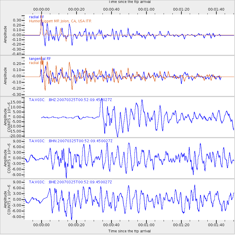
Signal To Noise
| Channel | StoN | STA | LTA |
| TA:V03C: :BHN:20070325T00:52:09.450027Z | 1.8522297 | 1.4672846E-6 | 7.92172E-7 |
| TA:V03C: :BHE:20070325T00:52:09.450027Z | 2.7552545 | 2.3080474E-6 | 8.376894E-7 |
| TA:V03C: :BHZ:20070325T00:52:09.450027Z | 13.746483 | 8.396317E-6 | 6.107975E-7 |
| Arrivals |
| Ps | 8.5 SECOND |
| PpPs | 27 SECOND |
| PsPs/PpSs | 36 SECOND |


