You are here: Home > Network List > TA - USArray Transportable Network (new EarthScope stations) Stations List
> Station V03C Hunter Liggett MR Jolon, CA, USA > Earthquake Result Viewer
V03C Hunter Liggett MR Jolon, CA, USA - Earthquake Result Viewer
| Earthquake location: |
Tonga Islands |
| Earthquake latitude/longitude: |
-20.2/-174.1 |
| Earthquake time(UTC): |
2006/05/03 (123) 15:26:40 GMT |
| Earthquake Depth: |
55 km |
| Earthquake Magnitude: |
7.2 MB, 7.8 MS, 7.9 MW, 7.9 MW |
| Earthquake Catalog/Contributor: |
WHDF/NEIC |
|
| Network: |
TA USArray Transportable Network (new EarthScope stations) |
| Station: |
V03C Hunter Liggett MR Jolon, CA, USA |
| Lat/Lon: |
36.02 N/121.24 W |
| Elevation: |
336 m |
|
| Distance: |
75.0 deg |
| Az: |
42.008 deg |
| Baz: |
230.845 deg |
| Ray Param: |
0.05184469 |
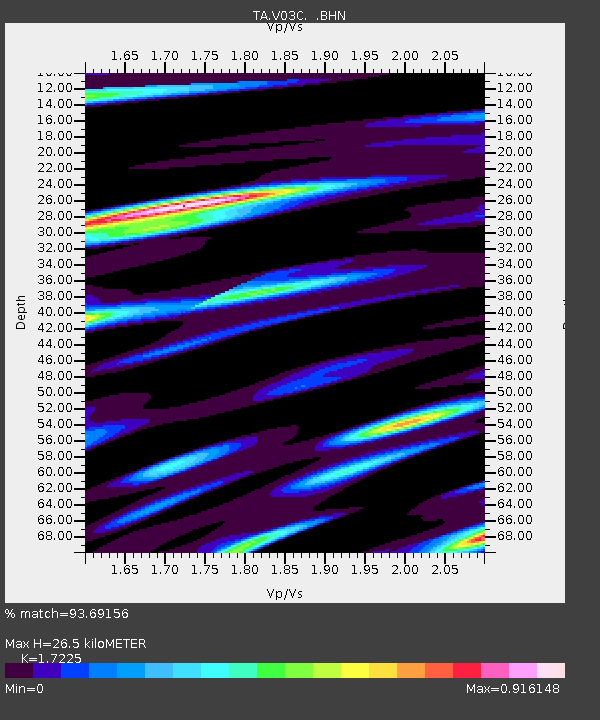
| Estimated Moho Depth: |
26.5 km |
| Estimated Crust Vp/Vs: |
1.72 |
| Assumed Crust Vp: |
6.391 km/s |
| Estimated Crust Vs: |
3.71 km/s |
| Estimated Crust Poisson's Ratio: |
0.25 |
|
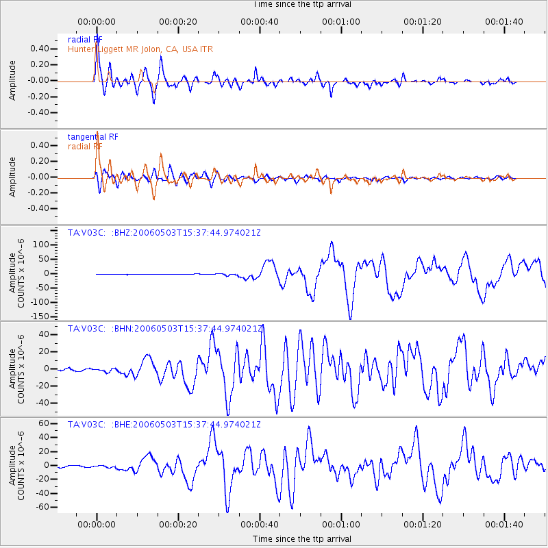
| Radial Match: |
93.69156 % |
| Radial Bump: |
400 |
| Transverse Match: |
82.63256 % |
| Transverse Bump: |
400 |
| SOD ConfigId: |
2669 |
| Insert Time: |
2010-03-07 04:06:17.648 +0000 |
| GWidth: |
2.5 |
| Max Bumps: |
400 |
| Tol: |
0.001 |
|
Signal To Noise
| Channel | StoN | STA | LTA |
| TA:V03C: :BHN:20060503T15:37:44.974021Z | 1.9037472 | 1.8142703E-6 | 9.529996E-7 |
| TA:V03C: :BHE:20060503T15:37:44.974021Z | 1.1579045 | 1.2971691E-6 | 1.1202729E-6 |
| TA:V03C: :BHZ:20060503T15:37:44.974021Z | 5.14418 | 3.2329738E-6 | 6.2847215E-7 |
| Arrivals |
| Ps | 3.1 SECOND |
| PpPs | 11 SECOND |
| PsPs/PpSs | 14 SECOND |


