You are here: Home > Network List > IU - Global Seismograph Network (GSN - IRIS/USGS) Stations List
> Station HNR Honiara, Solomon Islands > Earthquake Result Viewer
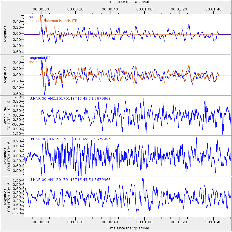
HNR Honiara, Solomon Islands - Earthquake Result Viewer
*The percent match for this event was below the threshold and hence no stack was calculated.
| Earthquake location: |
Northern Molucca Sea |
| Earthquake latitude/longitude: |
0.0/125.1 |
| Earthquake time(UTC): |
2017/01/13 (013) 16:39:25 GMT |
| Earthquake Depth: |
46 km |
| Earthquake Magnitude: |
5.7 mb |
| Earthquake Catalog/Contributor: |
NEIC PDE/us |
|
| Network: |
IU Global Seismograph Network (GSN - IRIS/USGS) |
| Station: |
HNR Honiara, Solomon Islands |
| Lat/Lon: |
9.44 S/159.95 E |
| Elevation: |
100 m |
|
| Distance: |
36.0 deg |
| Az: |
106.147 deg |
| Baz: |
283.205 deg |
| Ray Param: |
$rayparam |
*The percent match for this event was below the threshold and hence was not used in the summary stack. |
|
| Radial Match: |
52.05998 % |
| Radial Bump: |
400 |
| Transverse Match: |
56.96706 % |
| Transverse Bump: |
400 |
| SOD ConfigId: |
1943534 |
| Insert Time: |
2017-01-27 16:42:03.568 +0000 |
| GWidth: |
2.5 |
| Max Bumps: |
400 |
| Tol: |
0.001 |
|
Signal To Noise
| Channel | StoN | STA | LTA |
| IU:HNR:00:HHZ:20170113T16:45:51.567996Z | 3.4217548 | 5.2729393E-7 | 1.5410045E-7 |
| IU:HNR:00:HH1:20170113T16:45:51.567996Z | 0.9460888 | 3.0658617E-7 | 3.2405646E-7 |
| IU:HNR:00:HH2:20170113T16:45:51.567996Z | 1.6424168 | 4.063756E-7 | 2.4742536E-7 |
| Arrivals |
| Ps | |
| PpPs | |
| PsPs/PpSs | |


