You are here: Home > Network List > TA - USArray Transportable Network (new EarthScope stations) Stations List
> Station V04C Ramage Ranch, Paso Robles, CA, USA > Earthquake Result Viewer
V04C Ramage Ranch, Paso Robles, CA, USA - Earthquake Result Viewer
| Earthquake location: |
Northern Peru |
| Earthquake latitude/longitude: |
-5.7/-76.4 |
| Earthquake time(UTC): |
2005/09/26 (269) 01:55:37 GMT |
| Earthquake Depth: |
115 km |
| Earthquake Magnitude: |
6.7 MB, 7.5 MW, 7.5 MW |
| Earthquake Catalog/Contributor: |
WHDF/NEIC |
|
| Network: |
TA USArray Transportable Network (new EarthScope stations) |
| Station: |
V04C Ramage Ranch, Paso Robles, CA, USA |
| Lat/Lon: |
35.64 N/120.87 W |
| Elevation: |
431 m |
|
| Distance: |
58.6 deg |
| Az: |
318.026 deg |
| Baz: |
125.21 deg |
| Ray Param: |
0.062415455 |
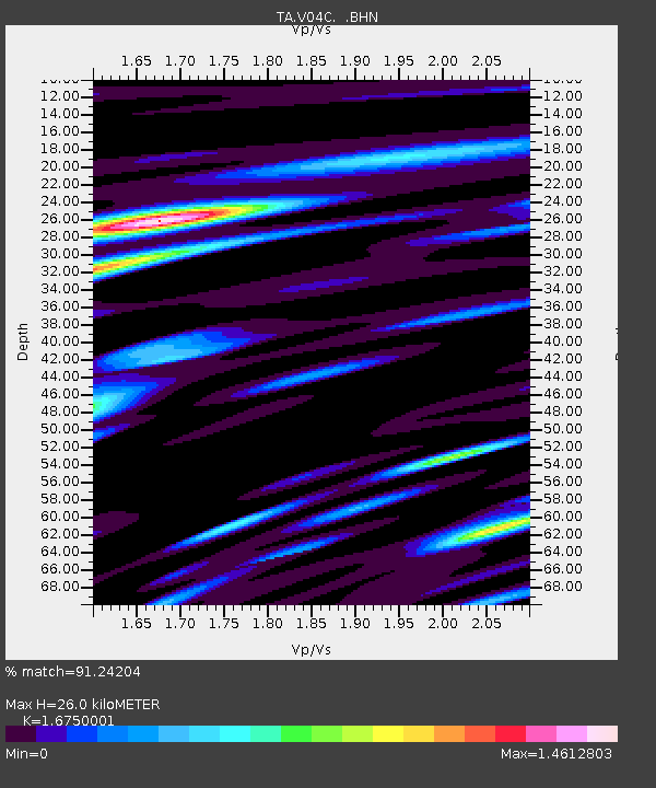
| Estimated Moho Depth: |
26.0 km |
| Estimated Crust Vp/Vs: |
1.68 |
| Assumed Crust Vp: |
6.183 km/s |
| Estimated Crust Vs: |
3.691 km/s |
| Estimated Crust Poisson's Ratio: |
0.22 |
|
| Radial Match: |
91.24204 % |
| Radial Bump: |
400 |
| Transverse Match: |
71.36575 % |
| Transverse Bump: |
400 |
| SOD ConfigId: |
2500 |
| Insert Time: |
2010-03-07 04:07:49.721 +0000 |
| GWidth: |
2.5 |
| Max Bumps: |
400 |
| Tol: |
0.001 |
|

Signal To Noise
| Channel | StoN | STA | LTA |
| TA:V04C: :BHN:20050926T02:04:51.643999Z | 12.472006 | 5.079449E-6 | 4.07268E-7 |
| TA:V04C: :BHE:20050926T02:04:51.643999Z | 15.896459 | 7.2509383E-6 | 4.5613544E-7 |
| TA:V04C: :BHZ:20050926T02:04:51.643999Z | 41.36409 | 1.7634953E-5 | 4.2633482E-7 |
| Arrivals |
| Ps | 3.0 SECOND |
| PpPs | 11 SECOND |
| PsPs/PpSs | 14 SECOND |


