You are here: Home > Network List > TA - USArray Transportable Network (new EarthScope stations) Stations List
> Station V04C Ramage Ranch, Paso Robles, CA, USA > Earthquake Result Viewer
V04C Ramage Ranch, Paso Robles, CA, USA - Earthquake Result Viewer
| Earthquake location: |
Near Coast Of Peru |
| Earthquake latitude/longitude: |
-13.4/-76.6 |
| Earthquake time(UTC): |
2007/08/15 (227) 23:40:57 GMT |
| Earthquake Depth: |
39 km |
| Earthquake Magnitude: |
6.7 MB, 7.9 MS, 8.0 MW, 7.5 ME |
| Earthquake Catalog/Contributor: |
WHDF/NEIC |
|
| Network: |
TA USArray Transportable Network (new EarthScope stations) |
| Station: |
V04C Ramage Ranch, Paso Robles, CA, USA |
| Lat/Lon: |
35.64 N/120.87 W |
| Elevation: |
431 m |
|
| Distance: |
64.3 deg |
| Az: |
320.862 deg |
| Baz: |
131.054 deg |
| Ray Param: |
0.05896406 |
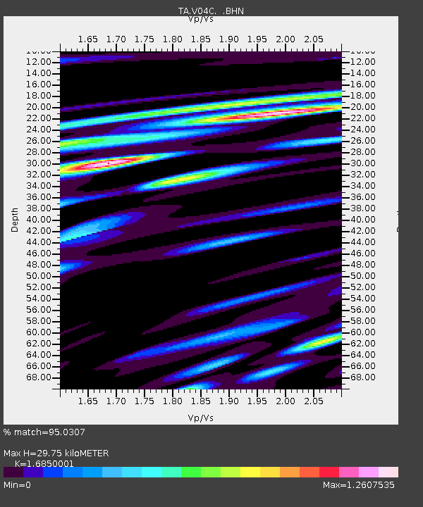
| Estimated Moho Depth: |
29.75 km |
| Estimated Crust Vp/Vs: |
1.69 |
| Assumed Crust Vp: |
6.183 km/s |
| Estimated Crust Vs: |
3.669 km/s |
| Estimated Crust Poisson's Ratio: |
0.23 |
|
| Radial Match: |
95.0307 % |
| Radial Bump: |
400 |
| Transverse Match: |
82.012146 % |
| Transverse Bump: |
400 |
| SOD ConfigId: |
2564 |
| Insert Time: |
2010-03-07 04:07:56.882 +0000 |
| GWidth: |
2.5 |
| Max Bumps: |
400 |
| Tol: |
0.001 |
|

Signal To Noise
| Channel | StoN | STA | LTA |
| TA:V04C: :BHN:20070815T23:50:58.319016Z | 1.270743 | 6.874621E-7 | 5.4099223E-7 |
| TA:V04C: :BHE:20070815T23:50:58.319016Z | 2.5118895 | 9.312016E-7 | 3.707176E-7 |
| TA:V04C: :BHZ:20070815T23:50:58.319016Z | 8.377049 | 1.9643228E-6 | 2.3448861E-7 |
| Arrivals |
| Ps | 3.4 SECOND |
| PpPs | 12 SECOND |
| PsPs/PpSs | 16 SECOND |


