You are here: Home > Network List > TA - USArray Transportable Network (new EarthScope stations) Stations List
> Station V04C Ramage Ranch, Paso Robles, CA, USA > Earthquake Result Viewer
V04C Ramage Ranch, Paso Robles, CA, USA - Earthquake Result Viewer

| Earthquake location: |
Fox Islands, Aleutian Islands |
| Earthquake latitude/longitude: |
52.5/-168.0 |
| Earthquake time(UTC): |
2007/07/15 (196) 13:08:00 GMT |
| Earthquake Depth: |
10 km |
| Earthquake Magnitude: |
5.8 MB, 5.9 MS, 6.1 MW, 6.0 MW |
| Earthquake Catalog/Contributor: |
WHDF/NEIC |
|
| Network: |
TA USArray Transportable Network (new EarthScope stations) |
| Station: |
V04C Ramage Ranch, Paso Robles, CA, USA |
| Lat/Lon: |
35.64 N/120.87 W |
| Elevation: |
431 m |
|
| Distance: |
37.1 deg |
| Az: |
97.936 deg |
| Baz: |
311.956 deg |
| Ray Param: |
0.0763188 |
| Estimated Moho Depth: |
20.5 km |
| Estimated Crust Vp/Vs: |
1.97 |
| Assumed Crust Vp: |
6.183 km/s |
| Estimated Crust Vs: |
3.146 km/s |
| Estimated Crust Poisson's Ratio: |
0.33 |
|
| Radial Match: |
91.75853 % |
| Radial Bump: |
400 |
| Transverse Match: |
87.83623 % |
| Transverse Bump: |
400 |
| SOD ConfigId: |
2564 |
| Insert Time: |
2010-03-07 04:08:05.946 +0000 |
| GWidth: |
2.5 |
| Max Bumps: |
400 |
| Tol: |
0.001 |
|
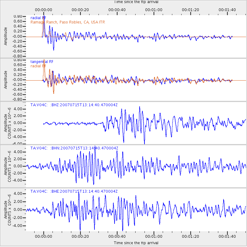
Signal To Noise
| Channel | StoN | STA | LTA |
| TA:V04C: :BHN:20070715T13:14:40.470004Z | 1.844994 | 4.8956747E-7 | 2.653491E-7 |
| TA:V04C: :BHE:20070715T13:14:40.470004Z | 2.6920028 | 5.887631E-7 | 2.187082E-7 |
| TA:V04C: :BHZ:20070715T13:14:40.470004Z | 5.1955714 | 9.557751E-7 | 1.839596E-7 |
| Arrivals |
| Ps | 3.4 SECOND |
| PpPs | 9.2 SECOND |
| PsPs/PpSs | 13 SECOND |


