You are here: Home > Network List > TA - USArray Transportable Network (new EarthScope stations) Stations List
> Station V04C Ramage Ranch, Paso Robles, CA, USA > Earthquake Result Viewer
V04C Ramage Ranch, Paso Robles, CA, USA - Earthquake Result Viewer

| Earthquake location: |
Mariana Islands |
| Earthquake latitude/longitude: |
21.0/144.7 |
| Earthquake time(UTC): |
2007/01/30 (030) 21:37:45 GMT |
| Earthquake Depth: |
30 km |
| Earthquake Magnitude: |
6.3 MB, 6.5 MS, 6.6 MW, 6.5 MW |
| Earthquake Catalog/Contributor: |
WHDF/NEIC |
|
| Network: |
TA USArray Transportable Network (new EarthScope stations) |
| Station: |
V04C Ramage Ranch, Paso Robles, CA, USA |
| Lat/Lon: |
35.64 N/120.87 W |
| Elevation: |
431 m |
|
| Distance: |
81.5 deg |
| Az: |
55.2 deg |
| Baz: |
289.609 deg |
| Ray Param: |
0.047498275 |
| Estimated Moho Depth: |
19.5 km |
| Estimated Crust Vp/Vs: |
1.94 |
| Assumed Crust Vp: |
6.183 km/s |
| Estimated Crust Vs: |
3.191 km/s |
| Estimated Crust Poisson's Ratio: |
0.32 |
|
| Radial Match: |
90.16627 % |
| Radial Bump: |
400 |
| Transverse Match: |
82.671265 % |
| Transverse Bump: |
400 |
| SOD ConfigId: |
2564 |
| Insert Time: |
2010-03-07 04:08:18.164 +0000 |
| GWidth: |
2.5 |
| Max Bumps: |
400 |
| Tol: |
0.001 |
|
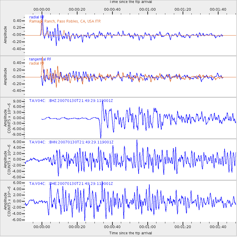
Signal To Noise
| Channel | StoN | STA | LTA |
| TA:V04C: :BHN:20070130T21:49:29.119001Z | 0.7140083 | 4.2973187E-7 | 6.018584E-7 |
| TA:V04C: :BHE:20070130T21:49:29.119001Z | 3.5414193 | 1.7438311E-6 | 4.9241027E-7 |
| TA:V04C: :BHZ:20070130T21:49:29.119001Z | 15.744488 | 4.456412E-6 | 2.8304586E-7 |
| Arrivals |
| Ps | 3.0 SECOND |
| PpPs | 9.1 SECOND |
| PsPs/PpSs | 12 SECOND |


