You are here: Home > Network List > TA - USArray Transportable Network (new EarthScope stations) Stations List
> Station V04C Ramage Ranch, Paso Robles, CA, USA > Earthquake Result Viewer
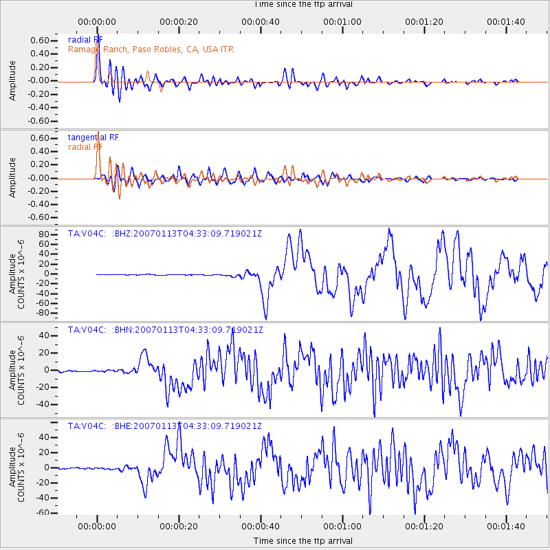
V04C Ramage Ranch, Paso Robles, CA, USA - Earthquake Result Viewer

| Earthquake location: |
East Of Kuril Islands |
| Earthquake latitude/longitude: |
46.2/154.5 |
| Earthquake time(UTC): |
2007/01/13 (013) 04:23:21 GMT |
| Earthquake Depth: |
10 km |
| Earthquake Magnitude: |
7.3 MB, 8.2 MS, 8.1 MW, 7.9 MW |
| Earthquake Catalog/Contributor: |
WHDF/NEIC |
|
| Network: |
TA USArray Transportable Network (new EarthScope stations) |
| Station: |
V04C Ramage Ranch, Paso Robles, CA, USA |
| Lat/Lon: |
35.64 N/120.87 W |
| Elevation: |
431 m |
|
| Distance: |
61.9 deg |
| Az: |
66.809 deg |
| Baz: |
308.45 deg |
| Ray Param: |
0.060569692 |
| Estimated Moho Depth: |
21.0 km |
| Estimated Crust Vp/Vs: |
1.94 |
| Assumed Crust Vp: |
6.183 km/s |
| Estimated Crust Vs: |
3.191 km/s |
| Estimated Crust Poisson's Ratio: |
0.32 |
|
| Radial Match: |
94.49755 % |
| Radial Bump: |
400 |
| Transverse Match: |
85.906364 % |
| Transverse Bump: |
400 |
| SOD ConfigId: |
2564 |
| Insert Time: |
2010-03-07 04:08:21.150 +0000 |
| GWidth: |
2.5 |
| Max Bumps: |
400 |
| Tol: |
0.001 |
|
Signal To Noise
| Channel | StoN | STA | LTA |
| TA:V04C: :BHN:20070113T04:33:09.719021Z | 1.4522705 | 9.0265456E-7 | 6.2154714E-7 |
| TA:V04C: :BHE:20070113T04:33:09.719021Z | 1.472425 | 1.1241759E-6 | 7.6348607E-7 |
| TA:V04C: :BHZ:20070113T04:33:09.719021Z | 5.0623226 | 2.4729745E-6 | 4.885059E-7 |
| Arrivals |
| Ps | 3.3 SECOND |
| PpPs | 9.6 SECOND |
| PsPs/PpSs | 13 SECOND |


