You are here: Home > Network List > JP - Japan Meteorological Agency Seismic Network Stations List
> Station JKA Kamikawa Asahi > Earthquake Result Viewer
JKA Kamikawa Asahi - Earthquake Result Viewer
| Earthquake location: |
South China Sea |
| Earthquake latitude/longitude: |
14.7/116.2 |
| Earthquake time(UTC): |
2019/09/05 (248) 13:58:34 GMT |
| Earthquake Depth: |
13 km |
| Earthquake Magnitude: |
5.3 Mww |
| Earthquake Catalog/Contributor: |
NEIC PDE/us |
|
| Network: |
JP Japan Meteorological Agency Seismic Network |
| Station: |
JKA Kamikawa Asahi |
| Lat/Lon: |
41.12 N/142.59 E |
| Elevation: |
220 m |
|
| Distance: |
34.9 deg |
| Az: |
35.991 deg |
| Baz: |
228.814 deg |
| Ray Param: |
0.077494316 |
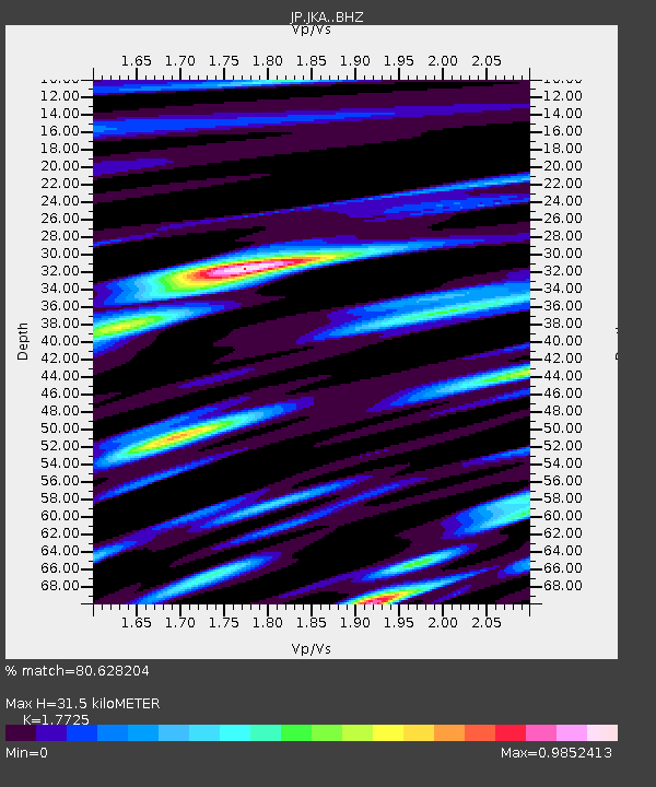
| Estimated Moho Depth: |
31.5 km |
| Estimated Crust Vp/Vs: |
1.77 |
| Assumed Crust Vp: |
6.183 km/s |
| Estimated Crust Vs: |
3.488 km/s |
| Estimated Crust Poisson's Ratio: |
0.27 |
|
| Radial Match: |
80.628204 % |
| Radial Bump: |
400 |
| Transverse Match: |
73.82301 % |
| Transverse Bump: |
400 |
| SOD ConfigId: |
19053131 |
| Insert Time: |
2019-09-19 14:03:35.453 +0000 |
| GWidth: |
2.5 |
| Max Bumps: |
400 |
| Tol: |
0.001 |
|

Signal To Noise
| Channel | StoN | STA | LTA |
| JP:JKA: :BHZ:20190905T14:05:12.649986Z | 0.9403779 | 1.2810852E-7 | 1.3623091E-7 |
| JP:JKA: :BHN:20190905T14:05:12.649986Z | 1.5566938 | 1.7940957E-7 | 1.15250394E-7 |
| JP:JKA: :BHE:20190905T14:05:12.649986Z | 1.0065842 | 8.860901E-8 | 8.802941E-8 |
| Arrivals |
| Ps | 4.2 SECOND |
| PpPs | 13 SECOND |
| PsPs/PpSs | 17 SECOND |


