You are here: Home > Network List > TA - USArray Transportable Network (new EarthScope stations) Stations List
> Station V04C Ramage Ranch, Paso Robles, CA, USA > Earthquake Result Viewer
V04C Ramage Ranch, Paso Robles, CA, USA - Earthquake Result Viewer
| Earthquake location: |
Vanuatu Islands Region |
| Earthquake latitude/longitude: |
-20.9/173.8 |
| Earthquake time(UTC): |
2005/08/09 (221) 05:26:17 GMT |
| Earthquake Depth: |
24 km |
| Earthquake Magnitude: |
5.5 MB, 6.0 MS, 6.1 MW, 6.1 MW |
| Earthquake Catalog/Contributor: |
WHDF/NEIC |
|
| Network: |
TA USArray Transportable Network (new EarthScope stations) |
| Station: |
V04C Ramage Ranch, Paso Robles, CA, USA |
| Lat/Lon: |
35.64 N/120.87 W |
| Elevation: |
431 m |
|
| Distance: |
83.6 deg |
| Az: |
48.139 deg |
| Baz: |
238.719 deg |
| Ray Param: |
0.046069622 |
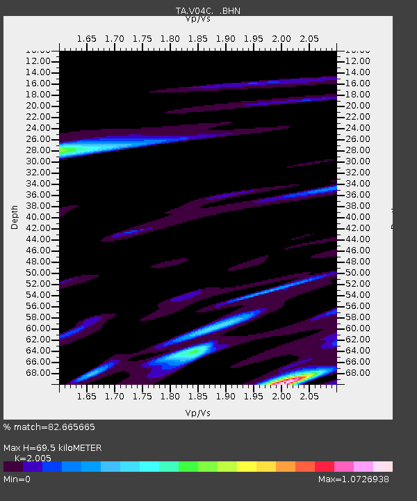
| Estimated Moho Depth: |
69.5 km |
| Estimated Crust Vp/Vs: |
2.01 |
| Assumed Crust Vp: |
6.183 km/s |
| Estimated Crust Vs: |
3.084 km/s |
| Estimated Crust Poisson's Ratio: |
0.33 |
|
| Radial Match: |
82.665665 % |
| Radial Bump: |
400 |
| Transverse Match: |
61.84732 % |
| Transverse Bump: |
400 |
| SOD ConfigId: |
132717 |
| Insert Time: |
2010-03-07 04:09:27.947 +0000 |
| GWidth: |
2.5 |
| Max Bumps: |
400 |
| Tol: |
0.001 |
|

Signal To Noise
| Channel | StoN | STA | LTA |
| TA:V04C: :BHN:20050809T05:38:12.269014Z | 1.1818106 | 2.0500256E-7 | 1.7346481E-7 |
| TA:V04C: :BHE:20050809T05:38:12.269014Z | 1.1435983 | 2.9189965E-7 | 2.5524668E-7 |
| TA:V04C: :BHZ:20050809T05:38:12.269014Z | 1.575572 | 3.323579E-7 | 2.1094428E-7 |
| Arrivals |
| Ps | 12 SECOND |
| PpPs | 33 SECOND |
| PsPs/PpSs | 45 SECOND |


