You are here: Home > Network List > TS - TERRAscope (Southern California Seismic Network) Stations List
> Station MLAC Mammoth Lakes, California, USA > Earthquake Result Viewer
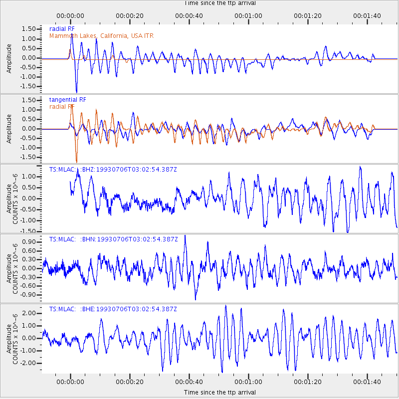
MLAC Mammoth Lakes, California, USA - Earthquake Result Viewer
*The percent match for this event was below the threshold and hence no stack was calculated.
| Earthquake location: |
Easter Island Region |
| Earthquake latitude/longitude: |
-24.6/-111.9 |
| Earthquake time(UTC): |
1993/07/06 (187) 02:53:03 GMT |
| Earthquake Depth: |
10 km |
| Earthquake Magnitude: |
5.5 MB, 6.1 MS, 5.9 UNKNOWN, 6.4 MW |
| Earthquake Catalog/Contributor: |
WHDF/NEIC |
|
| Network: |
TS TERRAscope (Southern California Seismic Network) |
| Station: |
MLAC Mammoth Lakes, California, USA |
| Lat/Lon: |
37.63 N/118.83 W |
| Elevation: |
2170 m |
|
| Distance: |
62.2 deg |
| Az: |
353.742 deg |
| Baz: |
172.818 deg |
| Ray Param: |
$rayparam |
*The percent match for this event was below the threshold and hence was not used in the summary stack. |
|
| Radial Match: |
86.375885 % |
| Radial Bump: |
400 |
| Transverse Match: |
62.692684 % |
| Transverse Bump: |
400 |
| SOD ConfigId: |
4480 |
| Insert Time: |
2010-02-26 14:28:23.439 +0000 |
| GWidth: |
2.5 |
| Max Bumps: |
400 |
| Tol: |
0.001 |
|
Signal To Noise
| Channel | StoN | STA | LTA |
| TS:MLAC: :BHN:19930706T03:02:54.387Z | 1.6257877 | 1.8658004E-7 | 1.14762855E-7 |
| TS:MLAC: :BHE:19930706T03:02:54.387Z | 1.7719553 | 6.1621574E-7 | 3.477603E-7 |
| TS:MLAC: :BHZ:19930706T03:02:54.387Z | 0.9828527 | 4.539643E-7 | 4.6188438E-7 |
| Arrivals |
| Ps | |
| PpPs | |
| PsPs/PpSs | |


