You are here: Home > Network List > US - United States National Seismic Network Stations List
> Station WMOK Wichita Mountains, Oklahoma, USA > Earthquake Result Viewer
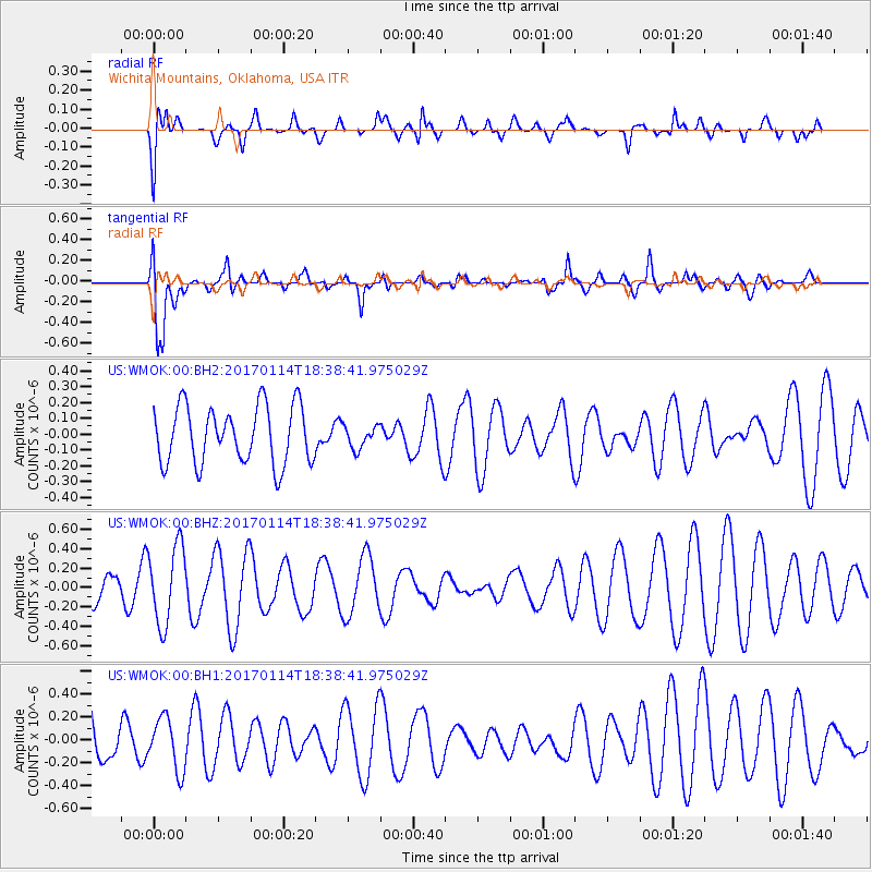
WMOK Wichita Mountains, Oklahoma, USA - Earthquake Result Viewer
*The percent match for this event was below the threshold and hence no stack was calculated.
| Earthquake location: |
Fiji Islands Region |
| Earthquake latitude/longitude: |
-18.7/176.1 |
| Earthquake time(UTC): |
2017/01/14 (014) 18:25:43 GMT |
| Earthquake Depth: |
4.6 km |
| Earthquake Magnitude: |
5.7 Mww |
| Earthquake Catalog/Contributor: |
NEIC PDE/us |
|
| Network: |
US United States National Seismic Network |
| Station: |
WMOK Wichita Mountains, Oklahoma, USA |
| Lat/Lon: |
34.74 N/98.78 W |
| Elevation: |
486 m |
|
| Distance: |
96.5 deg |
| Az: |
55.687 deg |
| Baz: |
251.97 deg |
| Ray Param: |
$rayparam |
*The percent match for this event was below the threshold and hence was not used in the summary stack. |
|
| Radial Match: |
62.39079 % |
| Radial Bump: |
400 |
| Transverse Match: |
51.331112 % |
| Transverse Bump: |
400 |
| SOD ConfigId: |
1943534 |
| Insert Time: |
2017-01-28 18:28:05.837 +0000 |
| GWidth: |
2.5 |
| Max Bumps: |
400 |
| Tol: |
0.001 |
|
Signal To Noise
| Channel | StoN | STA | LTA |
| US:WMOK:00:BHZ:20170114T18:38:41.975029Z | 2.0196688 | 4.031453E-7 | 1.996096E-7 |
| US:WMOK:00:BH1:20170114T18:38:41.975029Z | 0.72354 | 2.2813762E-7 | 3.1530752E-7 |
| US:WMOK:00:BH2:20170114T18:38:41.975029Z | 0.3910959 | 7.086199E-8 | 1.8118826E-7 |
| Arrivals |
| Ps | |
| PpPs | |
| PsPs/PpSs | |


